Day 2 – 27th January 2013 – Belvedere to Gravesend

IMG_2824 - Copy
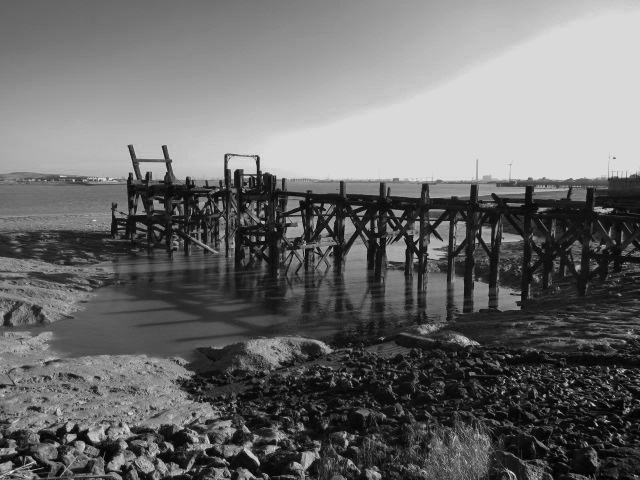
We picked up the path at Belvedere again, walking for a mile on the Green Chain Walk back to the coast at Erith Marshes.  We walked several miles with mud flats to our left and new housing to our right.  In the distance we could see the Queen Elizabeth Bridge crossing the river at Dartford.  It is an absolutely enormous structure and dominated the skyline.  Despite the forecast, it was another wonderful, blue day.  As we marched on we saw a number of derelict piers and old shipping lying on the shore – very picturesque, but sad.  The coast line has changed significantly over the years, with new salt marsh gradually growing – we walked along a great spur of this, turning back in past the ruins of a moated castle originally built by William the Conqueror’s brother, Odo, Earl of Kent, to guard the estuary and lived in until 1935.

Unfortunately, the map appeared to show a crossing at the mouth of the River Darent – the border between London and Kent, but actually, the feature was a massive tidal barrier which IMG_2838
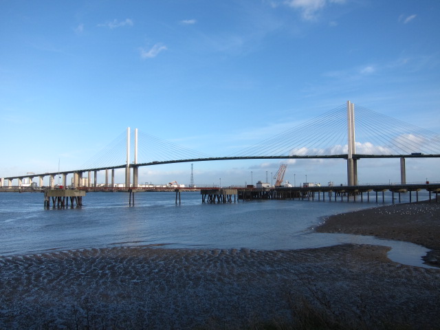
could not be crossed.  We had to make a huge detour in land and then pick up the path an hour and a half later, 20 yards away on the opposite side of the river.  This rather ate into the day’s progress.  We continued along the coast, less to see now, as the north side became more countrified, and the south still with random heavy industrial sites.  We approached the QE2 bridge around 3.15 and walked right under it, admiring the incredible beauty and the huge engineering feat it represents.  The path stops not far away at Greenhithe, and does not reach the coast again until Gravesend, but winds through industrial estates. We finished at Gravesend by the statue of Pocahontas, then adjourned to the pub – another great day.

Advertisement

Day 1 – 26th January 2013 – Monument to Belvedere.

Big thank you to Andrew, Yvonne and Sarah for coming and giving moral support and taking pictures – the best of a fabulous set of images is the new site banner. Bridget and I arrived at the Monument just after sun up.  It was a beautiful, fresh, blue morning, the sun sparkling on the River Thames and the tower blocks gleaming in the clear air – the Shard looked particularly impressRemitMTRndUK-2ive and acted as a landmark for most of the day.  Owing to the curves of the river, it sometimes seemed to be south as well as west of us, but just as frequently appeared to be to the north – quite disconcerting.

After a quick coffee, we started at the Monument, crossed London Bridge and dropped onto the Thames Path.  We followed this all morning, past the Tower, through Rotherhithe and Deptford down to Greenwich by lunchtime.  As we travelled we continually looked to the North side of the river to admire the skyline but there was plenty of interest on the south side too.  We saw the church in Rotherhithe with a memorial to the Mayflower, and a suitably ancient pub opposite of the same name, and then came across the City Farm – it was bizarre seeing sheep, goats and chickens with a backdrop of Canary Wharf.  (See Pubs, Cafes and B & B page for more).

Deptford still has a traditional parish church, with a mediaeval tower and 17th century main structure.  Everywhere along this stretch was full of the history of London and Britain – the great trade route of the Thames, the heart of our economy for two thousand years.  The massive wharves, although now converted to other uses still carry a faint scent of spice and chocolate.  The great Royal Dockyards and the Royal Naval School and hospital at Greenwich from the heyday of Samuel Pepys and Charles II reminded me of the early development of free trade and the growth of the Royal Navy to protect the trade routes.

Once beyond Greenwich, the scenery became much more bleak.  The whole stretch out to the 02 was derelict and deserted, apart from the aggregate yards, where diggers were moving heaps of dredged material from the left to the right.  The 02 itself still looks wonderful, and we were tempted to join the party climbing over the roof, but decided it looked a bit high! On we went through Woolwich, and past the Royal Arsenal at Woolwich.  The sun was still bright, but it was feeling like a winter afternoon as we passed a range of particularly noxious factories and sewage plants.  We turned inward to pick up the train at Belvedere and return home to a bottle of well-earned champagne to toast our efforts.

All set for the off…

I have cleaned out my camelbak with bicarbonate of soda as it smelt rather peculiar, found my attractive woolly hat and waxed my boots.  I used a traditional beeswax rather than Nikwax, so I hope it is effective.  Looking at tomorrow’s forecast, it will need to be!   I don’t like wearing plastic trousers over my ordinary ones, so I indulged myself in the Rohan sale with a pair alleged to be fully water and windproof.  I don’t think the Thames Estuary will be my biggest climatic challenge, but you never know.

I tried measuring the map more accurately using the measuring tool, but frankly, I think it was a waste of money.  I may not be very patient or dextrous (in fact I am certainly neither patient nor dextrous) but it was very fiddly to use, and I don’t think it is a lot more accurate than looking at the grid lines and calculating by eye.  Always keen for a gadget, I had a demonstration of a rather fancy GPS thingy, but can’t convince myself that it is worth it.  Certainly not at present.  You still need to carry a map (and compass if you are in more remote territory than North Kent), and, if you want to download a 1:25,000 map, you have to pay for the maps which, as they are around £130 for the equivalent of four or five real ones, would be incredibly expensive.  It will tell you how many calories you have burnt though!  Not sure if that is a good thing or not – I have some delicious Green & Black Fair Trade Chocolate to counteract promptly any excess calorie burning.

Early bed tonight, planning an 8am start from London Bridge in order to finish by mid-afternoon – I need to break myself in gently!

A friend for the first section!

I am delighted that my friend and colleague, Bridget, will be setting out with me on Saturday – it will be great to share the start with someone.  Andrew, our in-house photographer, is coming to see us off at 8am from London Bridge if anyone wants to come along for a laugh.  We will be leaving on the Thames Path and aiming for Erith.

I bought some more maps today to plan the next section in more detail – it is a logistical nightmare already, but so many people have said they would like to join me that it seemed a good idea to start putting dates up – see them on the Route Page.  I am getting my maps from a traditional newsagent in Hitchin (Merryfields at 16 – 17 Sun Street) which keeps a complete set. The shopkeeper thought I was absolutely barking when I walked out with 7 maps.  I have also bought a pedometer, on Neil’s advice, so I can see if the coast really is infinite!

Funnily enough, everyone interested has said that they would like to come along when the weather improves.  So far,  Deb, Graham, Howel, Jon, Liz, Magdalena, Neil (also volunteering his wife) Sally, Shirley, Susan, and my sister, Joy, are volunteering.  The West Coast of Scotland and Wales seem to be popular choices – but I shan’t get to those for some time!

Off to dubbin my boots…

The idea…

Hi to all of my friends,

I have sent you this link because it is easier than confessing my crazy idea to you all individually.

My plan is to walk all around the coast of Britain.  You may well wonder why, and in fact, I have no good answer to that question – I just want to!  I am not doing it for charity, although if my insanity moves you to make a charitable donation, my preferred destination would be The Guide Dogs Association – you can do it through this link to  http://www.justgiving.com/Melita-Thomas

The first question everyone asks is “how far is it?”  Bizarrely, owing to “fractal behaviour” the coast is infinitely long!  See this explanation at http://www.cartography.org.uk

However, for practical purposes, it has been calculated at 11,072.76 miles (17,819.88 kms). This figure is derived from 1:10,000 maps, and represents the length of the mean high water mark. I guess I could round it up to 11,073 to be more impressive! I shall be using a handy little map measuring device from Silva to measure my exact distances.

The second question, is “how long will it take?”  A few people have done it, and if you google you come up with people who have done it all in one go, and some who do it in pieces.  For the single trip brigade, it takes about 10 months to a year (although the quoted distances seem to vary wildly –  I have seen both 4,500 and 6,700 miles given as well as 19,000.   I suppose it depends on the exact route and whether you include islands.)  Other people have been at it for years.

I am planning to do it as quickly as I can, but, since I can’t practically take a year off I will have to do it in chunks.  The benefit of this is that I can ask people to join me, and I will be posting a list of anticipated times and stretches for people to volunteer themselves.  I would love to have all or any of you join me – the more the merrier.  I am starting with a couple of days on 26-27th January, and aiming to do at least one weekend per month, with longer stretches over Easter and other holidays.

“I can’t imagine Melita camping!” is another cry, and you are absolutely right!  I am certainly not planning to camp if I can possibly avoid it – it’s all very well camping in South America, which I did for 12 weeks (accompanied by a large van to carry the stuff) but my only experience of camping in the UK with my friend Vicki resulted in a sodden tent and a quick dash back to her mum’s for tea!  I will be using B & B’s, Youth Hostels and, if any of you would like to offer me a bed, or have a friend with whom I could “sofa-surf” at any time I would be grateful.

I will be updating my progress each time I complete a section and tweeting when I have updated.  Follow me at RemitMT #mtwalk