Day 123 – Porth Clais to Porth Gain 17 June 2021

Day 123 – Porth Clais to Porth Gain 17 June 2021

If I never have another day as good as today, it will all have been worth it. Today was definitely a diamond day. The view was spectacular, the weather was perfect, the public transport was punctual and the food I eventually had was excellent. My only concern is the nagging misery in my left knee, which kicked in this afternoon. Hopefully, a slug of ibuprofen tonight and in the morning will keep it under control.
I left the car at Porth Clais, which appears to be a busy little working port. The Strumble Shuttle took me from the end point into St David’s, and then the Celtic Coaster took me down to my starting point at a Porth Clais. Unfortunately, it had not crossed my mind to apply the time I had in St David’s yesterday to the useful purpose of buying provisions, hence, once again, I had no breakfast other than the handful of cashew nuts that remained. I was too early for the kiosk at Porth Clais, but had checked that there was a restaurant at Whitesands.

Ramsay Island, not, as I had thought, St David’s Head.

The west side of the steep valley at Porth Clais has ruins from what appeared to be industrial buildings of the 19th century possibly for exporting some sort of minerals or slate. I noticed in the rocks a fair bit of green suggesting copper, or perhaps green slate. There are also two whitewashed stone erections on either side of the harbour mouth, the one on the south-west side being like an obelisk whilst that on the north east is like an old fashioned sugar loaf. Presumably they are to guide shipping in. The path climbed immediately up to the cliff, and wound in and out of the various coves and inlets. I could see what I thought was st David’s head and then the path turned east, as expected, but the inlet seemed far too deep for St Justinians which was the first bay I was expecting. Eventually, it became clear that the whole long arm that I had taken to be a peninsula, was in fact Ramsey island. On the map, it is not shown in its proper place, but in a separate box and I had no idea that it was so close.

Busy St Justininian’s, with lifeboat.

St Justinians has the lifeboat, and also a brisk trade in island tours to Ramsey, Skomer and others. There was a boat load preparing as I arrived. I had a faint moment when I thought the thirty odd people were queuing for the coffee kiosk which was a site for sore eyes, but fortunately not. I listened to the guide. Apparently, there are some 40,000 breeding pairs of puffins on Puffin island. Ramsey used also to be full of them, but shipping run aground in the dangerous waters of the Sound, had brought rats to the island which had eaten all the eggs, and presumably the pufflings (my new favourite word) as well.  The rats have been eradicated now, but the puffins have not yet returned, although the guide said that the conservation body has planted decoys and played what she ever referred to as ‘puffin music’, but so far, although the birds have been seen in the water, they have not returned.

Whitesands Bay from the south-west

I went on to Whitesands which is a lovely beach, very popular with surfers. It is not exactly Manly, but I imagine in rough weather that the waves would be impressive. There was a café there,  but it had a long queue, and looked uninspiring so I decided not to bother – the double layer Victoria sponge at St Justinians had staved off the worst pangs. From Whitsands the path goes to St David’s Head, and then turns north-eastish, beginning the coast’s long stretch south of Cardigan bay. Not far past the headland, I coaught site of the flashing light of Strumble Head lighthouse – tomorrow’s destination.  The path was very busy, and I chatted to quite a few people. Beyond Whitesands, the scenery changed noticeably. Although the coast is still punctured by inlets, the rocks have changed, no more of the dark red stone visible near St Bride’s, or the sandstone along the stretch to Newgale; here it becomes slate and granite. Inland, too, the slopes are rolling moorland, with lumps of uneroded granite making peaks. I didn’t spot what made it feel so different until I heard someone on the path saying that the difference between north and south Pembrokeshire, is that in the former, there are very few trees, and thinking back over the day, that is true. I met a nice couple from Ross-on-Wye, not far from my new home and had a bit of a chat.

Seals between Whitesands and Abereiddy

The wildflowers were amazing. Although the daffodil is the national flower, I think a case could be made for foxgloves. They are everywhere, along with thrift, vetches of various sorts, ox eye daisies, lots of red campion and purple scabious. Even a few late patches of bluebells were clinging to the cliffs. I was lucky enough to see some seals, 5 or 6 of them playing in the waves. It is 7.6 miles from Whitesands to Abereiddy, another little surfing beach. I was tiring by now, especially as there was a long steep down and up just before. But from Abereiddy, once you have climbed up, the cliff top is very flat, until Porth Gain. The remnants of industry were easier to see here, I assume slate mining. Then there was a wicked slate staircase, more like a ladder down to the quay, just to aggravate my knees.

I had an excellent meal in the Sloop Inn. I believe the Ship is more famous but the Sloop was excellent.

17 miles

Diamond

Advertisement
Day 108 – Porth Einon to Cheriton 24th July 2018

Day 108 – Porth Einon to Cheriton 24th July 2018

We promised ourselves that we would start earlier today, and we did a bit better than yesterday, finding somewhere to leave one car and wriggling all the way through the lanes to cross Gower from north to south for 9am.  The morning was somewhat overcast, but it was not raining, and the forecast was good. We set out along the east side of the headland at Porth Einon, climbing up past a campsite, and looking back across to the headland we were on yesterday.  There is a

IMG_4259

View east from Porth Einon

monument stone at the top, dedicated to Gwent Jones (1910 – 1962) and Stephen Lee (1889 – 1962), described as ‘Dau gyfaill gwyr’ – two faithful men, who, as members of the Gower Society, helped preserve the cliffs.

Their work was well done – the cliff top walk is fine walking. We were pleased to see some ponies enjoying the view, too.Ponies above Porth Eynon 24.7.18 
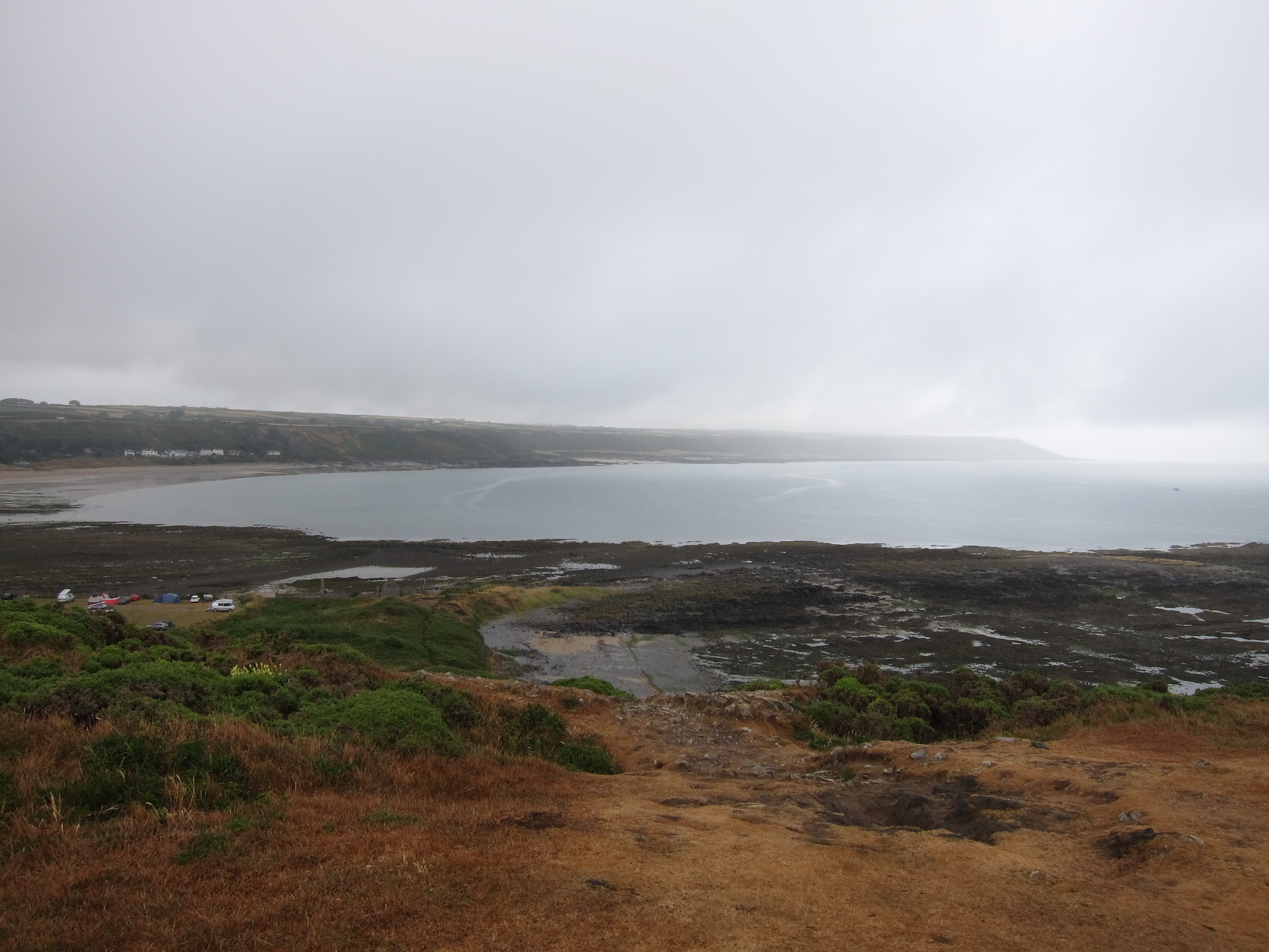
The tide was out, showing how the cliffs have developed over millennia, rock thrusting up from the earth’s core, and being worn away by the constant pressure of the waves.  There are no trees on this stretch of path, nothing but gorse.  Although we have had rain the last couple of days, the grass is yellow and worn.

Around 10.15, the clouds began to clear. We were in hopes of finding a cliff-top café for coffee, but, once again, were disappointed.  The path winds in and out of the deep fissures in the cliff face – running inland for a few hundred yards, down and up a steep slope then out again towards the sea. We were looking out for the famous Worm’s Head, but were not quite sure we had found it, until we passed it and looked back, then the shape of it is easy to sea. Nothing to do with worms, of course – ‘worm’ is a mediaeval term for a dragon.

The cliff tops were easy walking, and we soon began to see lots of other people with children and dogs.  Passing the Worm’s Head, we could see the curve of bay that is the delightful Rhossili beach – voted Wales’ best beach this year (2018) by Trip Advisor, and apparently in their top ten for the last six years.  And it is, indeed, spectacular – probably the best beach I have encountered so far in the whole walk.  Some of the Norfolk beaches might run it close for length and beauty of sands, but with the cliffs and the scenery round Rhossili also being magnificent, it is in a class of its own.

Rhossili Beach 24.7.18

Me overlooking Rhossili Beach.

On a more prosaic note, there is also a fine café, where we had a super lunch, overlooking the sea. To reach the beach, you need to go down a winding path and then steps.  The sun was getting stronger, and the sky bluer – ideal conditions.

The beach itself is completely flat – the sands are soft and pale gold, and the water was warm- we took off our boots and walked through it – very welcome to the feet after several days walking. The size and quantity of jellyfish was less pleasing.  As we walked north (the bay is at the end of the peninsula, and turns north), we could see lots of para-skateboarders. Not sure that is the right name – they have skateboard type things, with sails, racing along the sands.  Some of them went so fast they took off and it looked great fun – shame I am too much of a wimp to give it a go.

The path climbs up the cliffs, to a hillier section. On this stretch, there is no beach – the rounded green hills just drop straight into the sea,  and you can see across the estuary of the Llwchwr into the county of Carmarthen.  Llanmadoc beach and the Llwchwr estuary 24.7.18We then curved round and down into some sand dunes, and the path meandered down to the beach at Llanmadoc   The beach went for miles, extending into an area called Whiteford Sands along a spit, and, for me, was quite as impressive as Rhossili. We kept thinking we must have reached the end, but the beach curved on and on for nearly four miles.  At the northern-most tip, it swung back on itself and the path went inland. To our left was a vast expanse of wetlands and marsh.  To our right,  a strip of woodland, Whitford Barrows, only a few hundred yards wide, but completely different scenery from the beach on the other side.Whitford Barrows 24.7.18

It used to be possible to cross the wetlands on a mediaeval sea wall at Cwm Ivy, but the wall was breached earlier this year, and has not been repaired. We therefore had to join the road and walk a mile or so along it, back to the pub, where I also picked up some good news about another project.

Unsurprisingly, with the views, the company and the weather, this was a diamond day – only my second. 18 miles.

Day 98 Avonmouth to Severn Tunnel Junction 20 December 2017

Day 98 Avonmouth to Severn Tunnel Junction 20 December 2017

I haven’t worked out the overall score for today, but although it feels in general like a bronze day, or perhaps a silver one, it is going to be recorded forever more as a diamond day, because of the sense of achievement, and the particularly special part I completed.

Today, I crossed the Severn Bridge. I have now completed all the way from the Humber Estuary to the Severn Estuary (except the last element along the Thames that will be the final weekend, and the 4 miles at Bigbury that are still haunting me). I think I can say, however, that I have completed the south of England and am now in beautiful Wales.

It was generally an easy day. I left at the crack of dawn from Clifton Down station and reached Avonmouth just as it was getting light – around 7.30am. The road through the docks was incredibly busy and smelly (there was definitely something very dead somewhere) and I could almost feel my lungs being coated with black slime as the lorries thundered past.IMG_2848

Eventually the path (part of the Severn Way) leaves the road and runs beside the railway track, between hedges of brambles.  At Severn Beach, the path becomes a promenade, where the early fishermen were out in force.

The fog that had been expected yesterday, turned up today, so although it was not cold, I could see very little of the view. There was no sign of the lower Severn Bridge, although I could hear traffic and the beeping of horns.  It was quite strange, as the bridge is so enormous, to know it was there, but invisible.  It did not emerge from the mist until I was no more than 30 yards away – and even then, I could only see the couple of pillars nearest me.  The sun was struggling to come through, and I hoped that it would come out to allow me to see the upper bridge, which was my crossing point.IMG_2861

I passed under the bridge, the trucks on the M4 roaring over my head, and continued along the promenade, which meandered for about half a mile, before turning inland and becoming a very easy track along dykes built to manage the salt marsh. Looking back, I could see the mist clearing and part of the bridge now visible. Ahead, there was still no sign of the second bridge.  The sun was trying harder, and the grass was glossy green.

The path led onto a lane, and I rejoiced to see the tip of what I thought was part of the bridge, only to realise it was a metal pylon from previous engineering works, but after another ten minutes, bits of bridge became fleetingly visible as the mist rolled back and partially broke up.IMG_2892

I reached Aust around eleven. I was so hungry I could have eaten my own arm. Normally, I don’t worry too much about food when walking, but obviously, I had not had enough breakfast. I debated walking into Aust to see if there were a shop, although it did not look hopeful, and I was reluctant to add a half mile each way. I whipped out the phone (normally well hidden and turned off when walking) and saw that the motorway services were not far. So I elected to cross the motorway, on a walkway across the toll-booths of the M48 and grab an early lunch.

Fortified, I returned to the south side and began the big adventure. The upside of it being misty was that there was little wind. I muffled up and pulled on my hood, but was not particularly cold. There is a walkway on either side,  but I had decided on the south side, as my original idea of going to Chepstow was superseded by the decision to carry on as far as Severn Tunnel Junction.IMG_2921

As I walked over, stopping for frequent pictures, I was amazed at the number of motorway maintenance vans that tootled up and down the walkway. Not sure where they were all going as they trundled along at 10 miles per hour, stopping for a chat as they passed each other.

Crossing the bridge took about twenty minutes.  I then joined the Wales Coast Path. I must say I am hugely impressed with the signage. At every point where there might be confusion, there is a marker, and the ones at the stiles are tall, with yellow tips, so you can see them as you scan the far side of a field, looking for the exit.

The path was easy, behind various factories, then down along the estuary shore. There was so much mud in parts, it nearly sucked my boots off, but the trip was uneventful. The only bovines were docile Welsh Blacks, not feisty Friesians, and so they paid no attention to me. I passed an ancient holy well site, dedicated to the Celtic king, Tewrig, who scored a nifty victory over the Saxons not far away. The statue of IMG_2934him showed him crowned, but unshod. An early example of ‘all fur coat and no knickers’, I suppose.

I won’t bore you all with the appalling Great Western Rail service back to Clifton Down:  suffice to say, it was not the highlight of the day.  17.5 miles