Day 51 – King’s Lynn to Sutton Bridge 1st July 2014

Sitting in the Pizza Express in King’s Lynn, trying to recover from a severe sense of humour failure. The day started well enough, and should have been very straightforward – 12.5 miles along a clearly marked public footpath along the edge of the Wash. Unfortunately, things didn’t turn out like that. I left my pub at 8am, in search of breakfast and found a greasy spoon – although I am now longing for some fruit, rather than eggs and bacon for breakfast.IMG_7253

I then made a detour to look inside the Minster, and very impressive it is. Some beautiful stonework as well as brasses from 14th century.

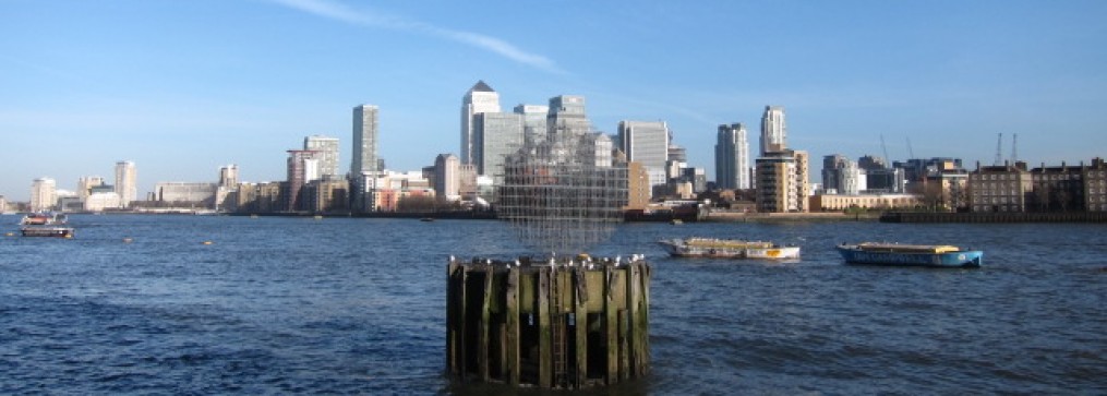
The day began overcast but looked as though it would clear up, which it did. I walked back down to the river bank and debated whether to turn south for the road bridge – a good mile each way to the bridge and back or to head for the ferry. Not having looked up the running times, I wasn’t sure if it would have started.

I opted for the ferry and was pleased to find it was already operating, although I missed one by a few minutes. However the ferryman is pretty brisk, and although the vehicle itself looks pretty clapped out, it does the job swiftly enough.IMG_7281

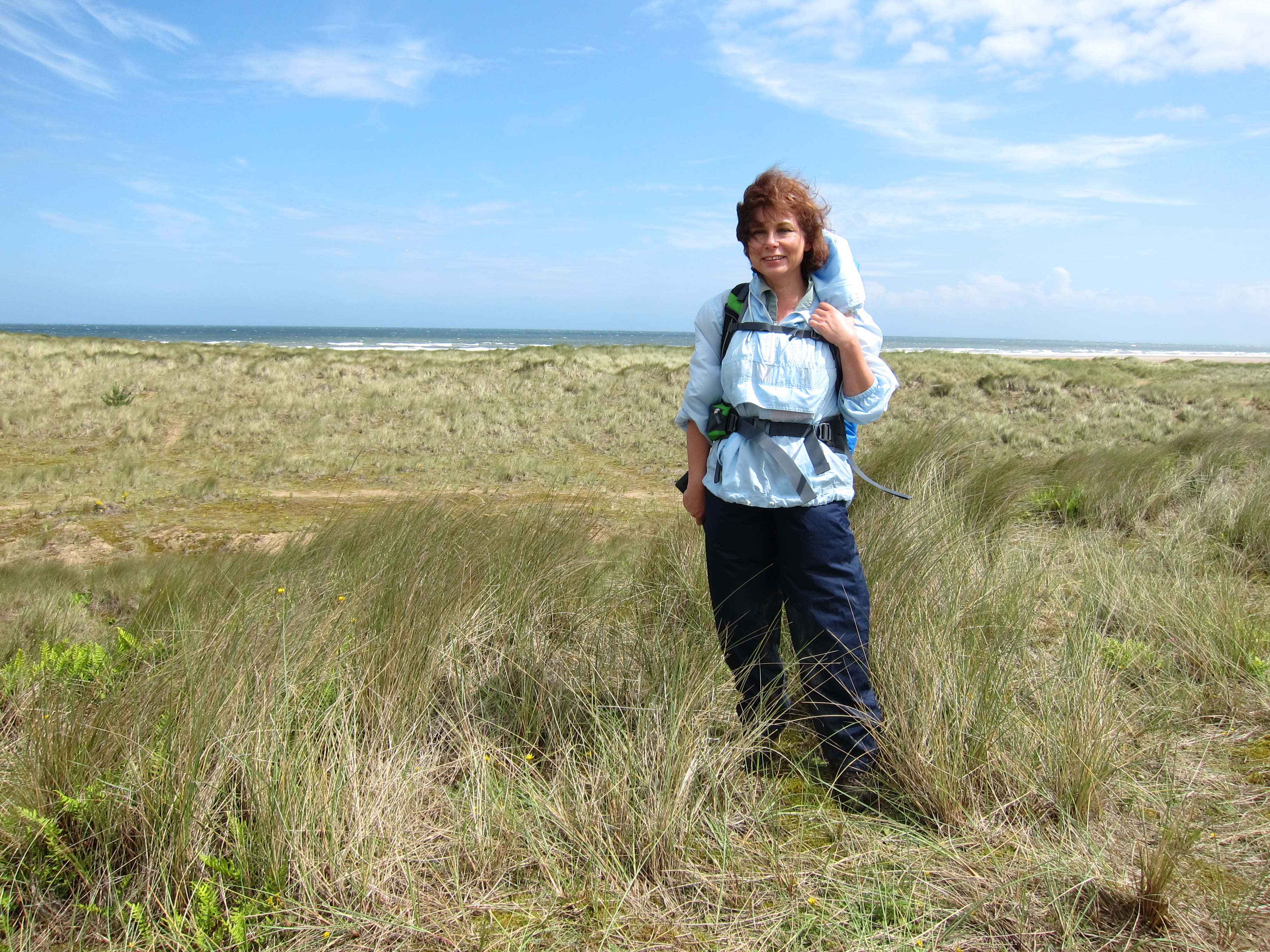
I landed at West Lynn in a few minutes, and had a look at the little exhibition about the draining of the fens before starting out on the Peter Scott Way. IMG_7282
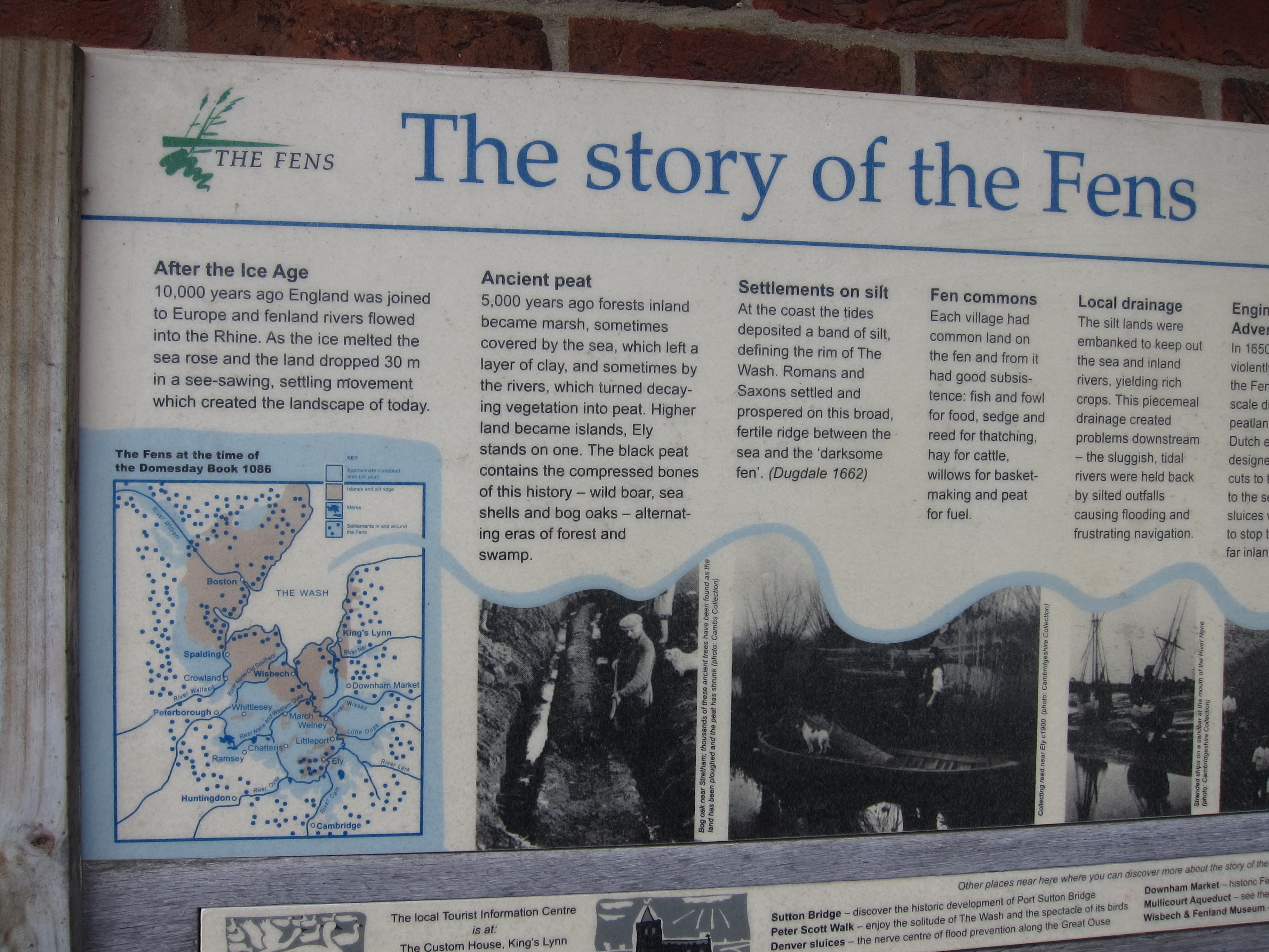
I had never heard of this path before which runs from the ferry at West Lynn to Sutton Bridge, along the edge of the Wash.   The sun was shining by now, with very little wind, and I was already glad of my hat. I sauntered on, making good time, and at around eleven decided to stop for 10 minutes to eat some chocolate and admire the view.

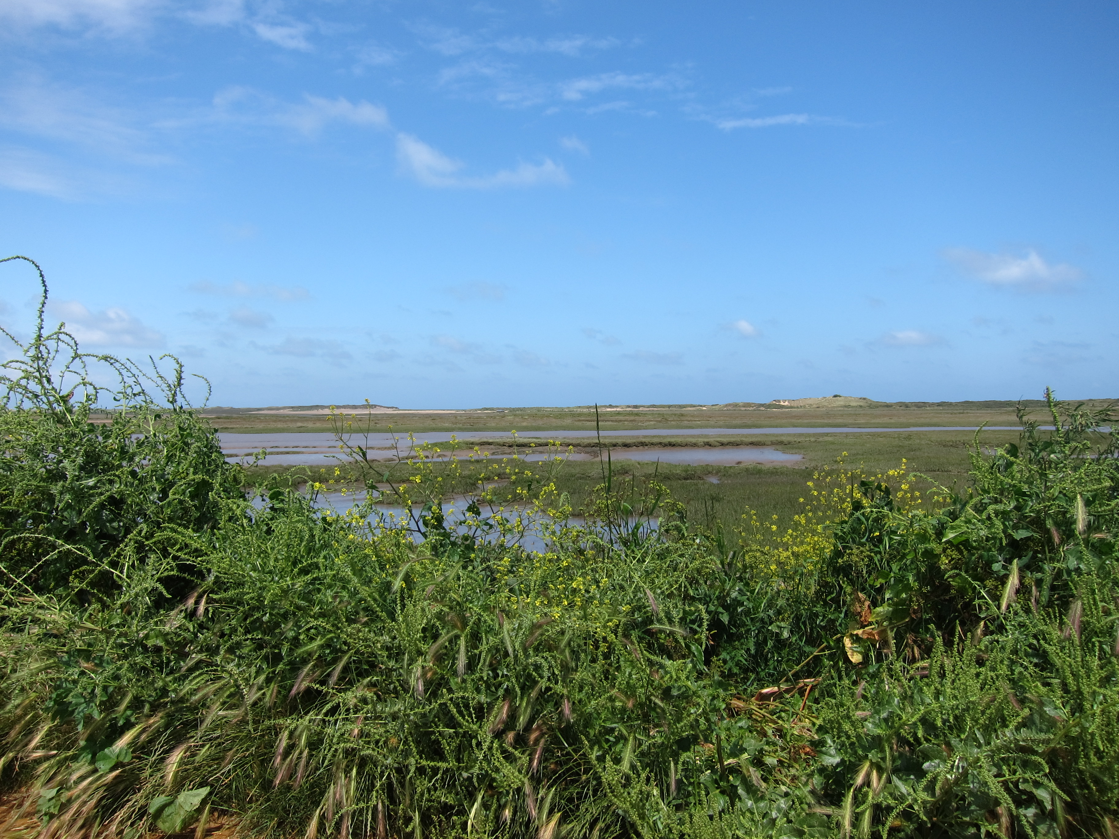
That 10 minutes cost me hours! I sat looking across the Wash back towards Snettisham where I had been yesterday, before my Sandringham jaunt. I contemplated the day ahead – easy walking, an unmistakeable route and no farm animals. I couldn’t have been more wrong!IMG_7296

Ten minutes later I approached a building that I had been able to see for some mile or so. I had thought it was an electricity substation, but as I got closer I saw it was a barn. I had no sooner registered this fact than a herd, or I might say a horde, of at least forty head of cattle poured out of the barn and stampeded up the bank. They were young male beef cattle, and presumably normally run down the other side of the bank to pasture on the grassy marsh edge.

To my utter dismay, they caught sight of me, not 50 yards away and the leaders stopped dead on the bank. Most of the rest followed them and I was faced with a herd of cattle and no way round. Now, I am not wild about passing cattle at the best of times but generally, if they are grazing quietly, I can slip through without drawing attention to myself.  There was no hope of that – they were curious, very curious, and whilst aggressive might be strong, they certainly weren’t friendly.

I yelled out in the hope that the farmer was there and had just let them out – he could have chased them off for me.   But there was no-one there. Presumably they just go in and out of the barn at their leisure.

I contemplated my options. There was no way I could go through them. I could go to the right down the bank and into the marsh but I didn’t know how tricky that would be. Besides, I would have had to cross their normal path. I considered going left between them and their barn. That didn’t seem too appealing either as there were still some left in the barn and I didn’t want them rushing out.   The third option was to go behind the barn and wait until they had lost interest. I slithered down the bank to the left and hopped over the five barred gate. It is amazing how swiftly I can move in these situations. I thought that if I hid for a bit, they would move off the bank, but no. Not a bit of it. I waited for a good fifteen minutes, but every time I emerged into view they would start to bellow.

Behind the barn was a large wheat field. I thought of walking along the edge of it, at the foot of the ridge, but the cows were still way too close for comfort.   I looked at the map and decided I should walk the half mile down the farm track, at right angles to the ridge, then run parallel with it and either cut back to it, or follow a ridge further inland that had been the 1910 water front.   So, off I went. Every time I looked back, the cows were still clustered on the ridge.

I got to the beginning of the next field – wide, open, East Anglian fields at least quarter of mile in length and width. I could see that there was a gate across the ridge footpath, so I thought I would cut back up, and climb back onto the path with the gate between me and the cattle.  First mistake.IMG_7305

The crops are pretty high now, and reached above my head. I kept close to the field which was not sown, but it was very tall grass, and cleevers everywhere, entangling themselves in my boots. I startled a few pheasants, but pushed on. I could see, as I approached the ridge that there was a wire fence, but I was pretty sure I could make short work of that. Imagine my horror when I found, not just a fence but a very wide drainage ditch, running parallel to the path which I couldn’t possibly cross. I looked at the map – sure enough, it was marked, but I had not checked carefully enough. Cursing, I decided to walk along the top of the field, which looked a bit less overgrown and down the other side to reach the 1910 ridge, rather than fight my way back down the way I had come. Second mistake – the field became even more overgrown. It must have taken the best part of an hour to get round the field and then, when I finally got to the 1910 ridge, that was so overgrown I couldn’t possibly walk on it.

The net result was that I had to walk all the way to Sutton Bridge on the road, with no sight of the sea. My socks and boots were full of burrs and cleevers and every step was prickly. Eventually, I bethought me of yesterday’s socks, dug into my rucksack and put those on – not that pleasant, but better than burrs.  The road was at least four extra miles as well.

My only piece of luck all day was coming into Sutton Bridge, and reaching the bus stop just as the bus was trundling up the road.

Day 50 – Hunstanton to King’s Lynn – 30th June 2014

I am very lucky to be sitting in a delightful, if somewhat expensive, bistro in King’s Lynn, overlooking the Great Ouse, rather than clapped up in the Tower of London.

I spent several hours today trespassing through the Sandringham estate. I didn’t set out to trIMG_7175espass of course, but I am not sure how I could have avoided it.

I left my B & B at Hunstanton, this time after a decent sized breakfast, around 8.45. The morning couldn’t have been lovelier. The sky was a clear blue and there was no wind at all. I walked down to the front and admired the Wash. Sunny Hunny was certainly living up to its name. High tide had just passed and the water was still lapping up to the sea wall. Yesterday’s wind meant the sea was still fairly choppy. Far to the north I could still see the enormous wind farm that was very noticeable from Holme- next-the-sea.

The promenade continues for several miles and although it is hard underfoot, makes for fairly brisk progress.IMG_7178 Eventually, the prom comes to an end and the nearest public foot path runs inland along the top of a bank, with a field to the seaward side and marsh inland. I continued along this for some time, kicking myself for having forgotten to bring my hat. I am very prone to sunstroke and the sun was blazing down relentlessly. I slapped Factor 50 all over myself but feared a bout of headache and nausea.

In due course I arrived at the delightfully named Snettisham Scalp: a little outpost on the coast, of the village of Snettisham. Even more pleasing was a cafe and beach shop where I was able to buy a straw hat for the princely sum of £1.99. I sat and had a coffee and relaxed for half an hour before heading onto the shore again. It is relatively easy to walk along the beach here, some shingle, but also hard packed sand. The tide had gone out a long way by this point and I lived in hope of finding King John’s Crown Jewels, lost in the Wash in 1216.  Sadly, no sign of them, but I will keep my eyes peeled tomorrow.IMG_7196

There are huge numbers of seabirds of all sorts, and also, sadly, lots of jellyfish exposed to the beating sun. Signs warned walkers about walking too close to plover nests. I did not see any although I am sure I wouldn’t recognise them anyway. But I did see a lot of oystercatchers. The whole area seems to be managed by the RSPB. On the inland side is a lagoon, with a steep bank between the lagoon and the beach along which is the foot path.

The map showed that at the south end of the lagoon, all of the tracks converge to cross a canal where there is a sewerage outflow but the lie of the land and the direction of tracks has changed since my map was published, mainly, I suppose, because of last December’s storm surge. In consequence I found myself on the wrong side of a barbed wire fence and gate, and had to exercise some ingenuity to get back onto the right track.. After some wriggling around, I reached a gate near the crossing point.

My map showed a series of paths apparently running along the tops of banks between marsh and fields, so I turned south along a bank near the sewage works. A track was running to the side, but I stayed high. I turned back towards the sea, but after about half a mile I came to a gate. I went through but the track was so over grown, I couldn’t continue. I decided to return to the point where the track split and take the track. Turning round, I saw a sign on the gate saying “Sandringham Estate, no public access.” However, I had no choice. I couldn’t continue as the path was so overgrown, and it would have been foolish to walk into the marsh.  I did refrain from taking photos on the Estate.

I had not fancied the track earlier, because of the sound of gunshot, but it was that or all the way back to Snettisham and round by the road. I didn’t think it was shooting season, being only the 30th June, but I not really up in these things. There was a van parked, with some dead duck under it, but no sign of life. As I walked along the track, I heard more gunfire but I didn’t see anyone.

I walked on and on, following the tracks, never seeing the sea, but sure it was there some half mile west of me. The Sandringham estate is clearly run for wildlife and shooting. There were many, many butterflies and other insects, and frequent sightings of pheasant and grouse.

A couple of hours brought me to a point where I could turn inland to follow a road and various other paths into King’s Lynn, which would have totalled at least four miles extra, or continue through the estate. Emboldened by the fact that I hadn’t seen a soul, I decided to press on, turning down a metalled road which did say ”Crown Estate: Private Road”, but not very noticeably, and anyway, there are lots of private roads that can be walked down, I argued to myself.  I checked the map and saw that the track led, eventually, to a little hamlet called South Outmarsh, where I could pick up the track next to the Great Ouse into kings Lynn. I decided to risk it. As I walked along a large farm vehicle went past – I held my breath lest the driver stop and challenge me, but he sailed on by. I carried on, then tuned left, in the same direction as the vehicle. Unfortunately, he hadn’t gone far but was in a yard, cleaning the vehicle. I effected an air of nonchalance as I walked through the yard.

“Excuse me, can I help you?,” a young man in mirrored shades, combat trousers and a tattoo overcoat asked me.

I feigned ignorance. “No, I am fine thank you.”

“It’s just that you are on private land.”

“Oh?”  I didn’t actually lie or say I didn’t know, merely fumbled with my map and said that I was trying to get to South Oumarsh.

“As soon as you took the road up here you were on private land.”

“Oh dear.” I tried to look confused and as much like a harmless middle-aged lady as I could, unfurling my map and saying, “There seems to be a track here.”

I smiled and took my sun glasses off. He recoiled, horrified by the windswept , red eyed apparition in front of him. His immediate thought was how to get rid of me as soon as possible.

“Look,” he took my map, “I am not sure where we are. I’ve lost my bearings.”

I pointed to the shed where we were standing, and to the village.

“Right,”   he said, “you go up there, and climb up to the rise, where there is a sluice. Cross the sluice and you will be alright. I am not giving you permission , mind, you are on private land.”

I smiled again. “Thank you SO much. I’ll be as quick as I can.” I scurried off, wondering what I would have done if I had been forced to go back. I expect I could IMG_7222have cried. However, that was unnecessary as he was very kind and polite and II was very glad not to have to make a detour of several miles.

Once over the sluice I stopped to have a celebratory piece of chocolate. Unfortunately, it had melted in the most disgusting fashion all over the inside of the rucksack. In the way of chocolate it promptly ran amok all over my face, hands and trousers. I must have looked a terrible sight.

I eventually reached the track beside the Ouse, visualising bars and boats and already savouring a crisp white wine. I was sadly disappointed. The stench of the dead and rotting fish was so appalling I almost gagged. No self- respecting wine bar would go anywhere near it.

The walk into King’s Lynn was a trudge, and I was very disappointed, initially, with the town which looked dirty and grim. I arrived at my pub at around 4.45 – the oldest continuously inhabited pub in King’s Lynn.

When I reached the heart of the town, I could see it was absolutely delightful – the huge Minster dedicated to St Margaret of Antioch, Mary Magdalene and All the Virgin Saints dominates the square flanked by Georgian facades with the mediaeval houses of the Hanseatic League behind. It is absolutely gorgeous – a real gem of a traditional English provincial town.IMG_7231IMG_7230 Down by the staithe, I finally found the bistro and bar with the glass of white wine I had been fantasising about. See review.

A modest 28 km today – 17.5 miles. I am glad to say the painful knee has resolved into a lightly pulled muscle rather than any joint problem. It is a nuisance and mildly painful, but can be walked through in about fifteen minutes and is not beyond the reach of paracetamol.

Day 49 – Wells-next-the-sea to Hunstanton

Another lovely day, although it did not start out very promising. After a rather low grade breakfast, Bridget and I stepped out into heavy rain to meet Chris and Rita at 9.30 back down on the front at Wells. Foolishly, I did not have my waterproof trousers on, and by the time I had gone 300 yards, my lower half was soaked. I found a covered area and struggled into them, just as the rain turned torrential. Bridget and I hovered under shelter for a few minutes, then, as it eased off, went on to meet the others. The weather was so appalling that I told them all I was quite happy to go on alone, and that I wouldn’t feel at all abandoned should they decide to do something more appealing than walk for 20 miles in a downpour, although I was sure that the sun would come out shortly.IMG_7096

Bridget and Rita elected to meet us later, but Chris valiantly stuck to Plan A. I promised it would be dry by 10am and sunny by 11am. He looked doubtful, but pretended to believe me. We walked along the old railway route directly north out of Wells for the best part of a mile. There is a little cafe at the end, and, since the rain had stopped, just as I promised, we went in to dry off and have an excellent coffee.

The Norfolk Coast path here runs though the Holkham estate, one of the biggest private estates in the country. Around 150 years ago, pine forests were planted by the estate as sea defences, and the path meanders through the woods, with the sea some quarter mile further out beyond the dunes. IMG_7101The weather improved, and, as I had predicted, at ten to eleven the sun broke through and the sky became blue and clear, although there was still a brisk wind. Once through Holkham woods, the path winds inland to a small village called Burnham Overy Staithe. Staithe is a northern or eastern word for a landing stage, and many of the small villages have them. Burnham Overy’s claim to fame is as the place where Lord Nelson first learnt to row and sail, before joining the Royal Navy as a Midshipman, aged twelve.

We walked on towards Brancaster Staithe. The countryside changed completely again – a raised ridge with marsh all around. IMG_7123There was another great feast of seabirds. I am practically becoming a twitcher! I have seen so many egrets now that I am becoming quite blasé about them. There were also lots of oyster catchers and something else that we could not identify for certain. A similar build to a swan, but fawn in colour. We though it might be a grebe (or rather several as we saw more than one) but we could not be certain  as we were too far away to see if they had crests.

All the while we walked along the ridge we could hear the wind rustling the miles of Norfolk reed beds, used for thatching since ancient times.IMG_7133IMG_7136

In Roman times, Brancaster was on the sea front, and an important fort on the Saxon Shore, the line of defences built, according to a common (although disputed) theory, to keep the Saxons from invading Britain. The sea is now a good mile further out.

About a mile out of Brancaster Staithe we were met by Bridget and Rita, who had found a good pub where we returned for lunch. Chris and I left at around 3.30 and carried on through to the main village, along a raised boardwalk through the reed beds.   We then continued along the road for a bit -the Norfolk coast path goes inland here, but we kept a bit closer to the sea, although it is far out beyond the salt marsh at this point. The sky looked very ominous, but, fortunately, it did not rain again.IMG_7168

I was beginning to tire – my left knee has been a bit temperamental today, following walking on shingle yesterday – not helped by stepping into a hole and jarring it. The salt-marsh and reeds receded and we back down by the beach, walking over sand dunes and rough marram grass. Fairly hard going, but lots of it has been boarded, so not too much of a struggle. Just after Holme-next-the sea, we met Bridget who had parked at Hunstanton and walked to meet us – another half hour along the dunes, and then the welcome site of Bridget’s car in the car park at the edge of the town. I am going to confess to a little cheating here as I begged a lift for the last mile to my B and B. I have now completed the whole Norfolk Coast path – 45 miles from Hunstanton to Cromer, taking 2.25 days. Today’s total was 31.4 km – 19.6 miles.

Day 48 – Sheringham to Wells-next-the-sea 28th June 2014

Just got into bed feeling completely exhausted. Last night, I hardly slept at all, behaving elected to stay at the Youth Hostel in Sheringham with Chris and Rita who walked with IMG_7023me today.

Unfortunately, I was in a shared dorm with two perfectly lovely women, who unhappily both snored like drunken sailors.   Now generally, one person snoring is just about bearable if it not too loud but both of them were appalling in both frequency and volume. I was reminded of the Ancient Mariner – they cracked and growled and roars and howled all night without ceasing, First in counterpoint, then in harmony, and finally in some devilish syncopation that kept me awake all night. Even the chickens at five am couldn’t bother me as I was ready wide awake.

Other than the noise the YH was good – excellent meal last night, though breakfast was indifferent.

Rita, Chris and I set out around 8.45 along the front at Sheringham. The forecast had been for torrential rain at 9am, but it did not materialise. We walked along for a half mile or so. Then, after going a little too far, and having to turn back, climbed up onto the low cliffs at the golf course.

The loveliest part of the morning was being surrounded by sky larks. I have never seen so many – not just in the air but on the ground too, and seemingly, unafraid of humans.   It really is the sound of a British summer. We walIMG_7044ked for about four miles on the cliff path. As well as the sky larks, we saw plenty of butterflies and also seven spotted burnet moths.

Our favourite sight of the day was a group of “fishermen.”  Well, their fishing rods were propped up, working away, but the chaps themselves were lolling on a large, inflatable sofa, with a cooler full of beer.  We thought they were probably watching the match on their phones at the same time.  No doubt they will return to their wives with stories of all the fish that got away.IMG_7061

Eventually we came down to the shingly beach at Weybourne, then turned inland to Salthouse where we stopped for a coffee. Rita left us there and Chris and I continued to Cley-next-the-sea (apparently pronounced cleye to rhyme with eye.) A number of these towns named “next-the-sea” really need to be renamed “used-to-be-next-the-sea-in-the-early-middle-ages,” often being a mile or so inland.

As we walked towards Cley we were delighted by the sight of a very elderly man, he must have been 90 plus, walking towards the sea with a collar and tie and tweed jacket and cap, long staff in his hand. We decided he had walked to the sea every day of his life since his was a nipper. He was very gentlemanly, and touched his cap to us as we passed.

Going through Cley, the path runs inland along the main road to cross a river.   Carelessly, Chris and I were so carried away by the delights of home-made Norfolk ice cream (I chose Norfolk Apple Crumble flavour – mmm!) that we missed the turning back towards the shore and took an accidental 2.5 mile detour, only discovered when Chris wondered why the sea was behind us instead of to the right. Grrr.

The Norfolk coast path is uneventful. It is hard going on the shingle areas, and the beaches today were all shingle, not like the beautiful sounds further east.  There are numerous churches along the way, all unfeasibly large, remnants no doubt of the days when East Anglia we the most prosperous, and populous area of the country after London.

We walked steadily though Blakeney, Morton and Stiffkey – no idea how that is pronounced, although we have heard that it is Stukey. We did come up with some interesting variants.  Well, I say we walked steadily. But the signage is poor and we often had to double back to find the track as it meanders through the wetlands. Despite predictions of violent storms and heavy rain, we encountered no more than a few drops. About a mile out of Wells, we met Sally and Trevor and, with the addition of Bridget, who will walk tomorrow, adjourned to the Albatross, a splendid floating pub in a converted Dutch Barge.

I am unusually tired tonight, both as a result of last night’s sleeplessness, and the detour that gave us an extra couple of miles, to make just over 20 rather than the planned 17.5. Also, I have been quite poorly for the last few weeks, and this is my first real outing. I hope I will be able to cover the distances planned.