Day 113 Talacharn to Saundersfoot 10 June 2019

Day 113 Talacharn to Saundersfoot 10 June 2019

I had an early start today, as I was leaving the delightful accommodation for a new location, so had to pack everything up and get to Saundersfoot in time for the bus. As it happens, I misread the timetable and left myself with nearly an hour to wait. The bus was then slightly delayed, which worried me, as I had a ten minute gap at Pendine to catch the second bus. However, the driver clearly believed in hitting his timetable, as he haired down the country lanes at a scary pace.

At the Pendine bus stop were another couple of walkers, from North Wales, so we had good chat. There was also a lady who clearly had some mental health issues. She asked me to watch her dog whilst she went back home for something. It was not clear why the dog could not go too. I told her I was catching the bus, and could not wait, but she assured me she would be back. The poor creature set up a tremendous torrent of barking. Another woman at the stop more-or-less told me that she does it all the time. I felt guilty when I got on the bus, and left the poor dog barking, but what else could I do?

IMG_4677

Dyklan Thomas’s 30th Birthday Walk.

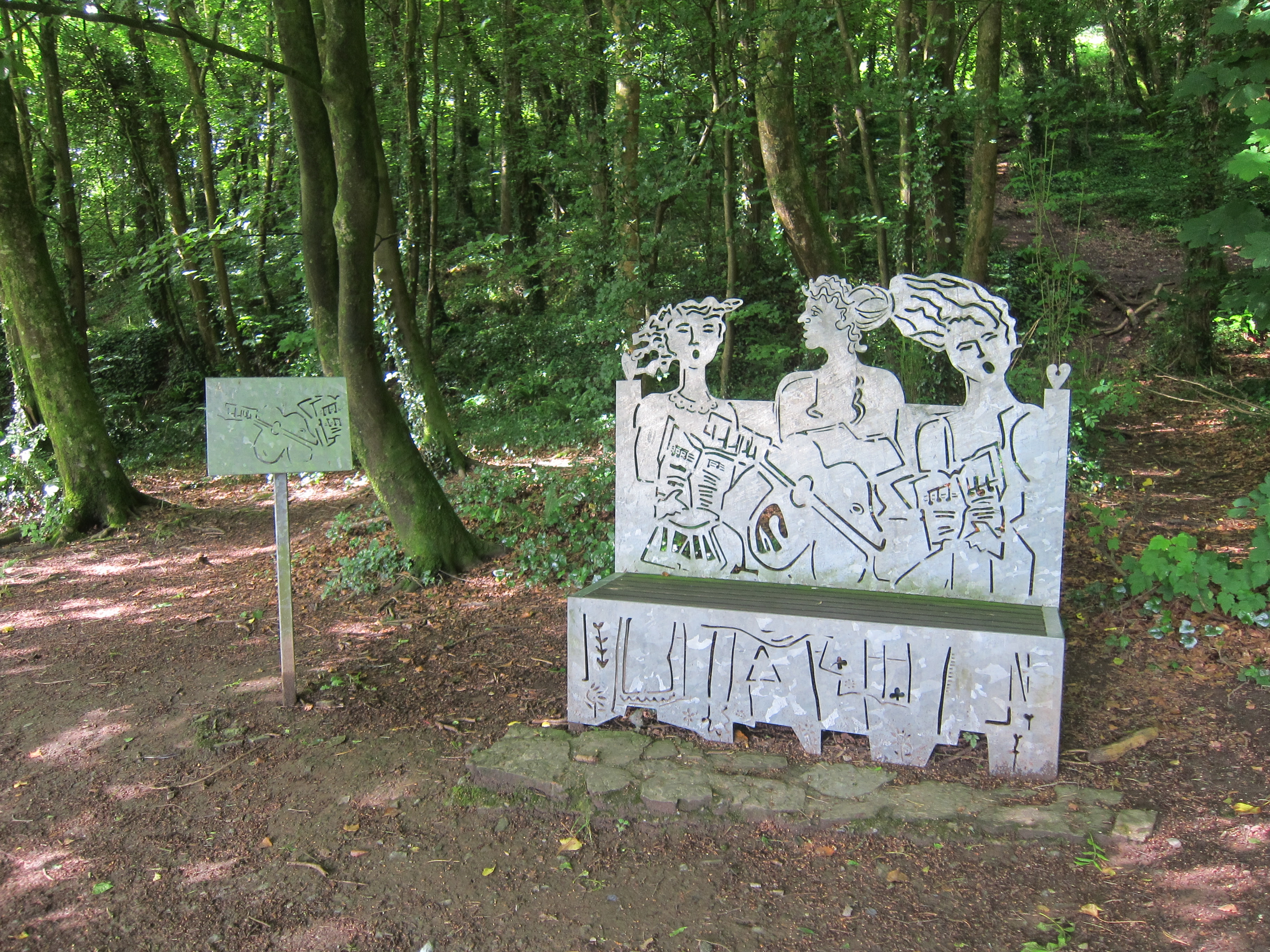
The sun was not so bright this morning, but Talacharn/Laugharne is still very pleasant, and the first 20 minutes of walking through the woods where Dylan Thomas did his famous walk, to celebrate his 30th birthday and wrote a poem about it, were lovely.

IMG_4679

Woods to the west of Talacharrn.

Then there was a long trek underneath the cliff on a paved track.  A rather depressing puppy-farm made a lot of noise, before the path turned up to the road. Once again, considerable effort has been made to keep the path off the tarmac, but the whole four miles was dull.  As we approached Pendine, which I discovered was the home of the land -speed record. I was amused by a sign announcing this, together with the words, ‘drive safely’.  Another sign for my new collection.

I was worried that as I passed the bus stop where I had boarded earlier, the dog might still be there, but fortunately, it was not. At the far end of Pendine, I bought a coffee and sat to eat my sandwiches, looking back along the amazing beach, where the land-speed record had been set, which, sadly, is largely closed to the public, as an MoD property. There was constant shooting in the background. The path climbs high up out of the village. I stopped at a viewpoint and chatted to a couple with a rather nice dalmation dog, named Jasper. The man’s brother is also walking the entire coast! Quite a coincidence, although I expect there is some statistical quirk that makes it all quite unsurprising. Like two people in every 23 having the same birthday.

IMG_4700

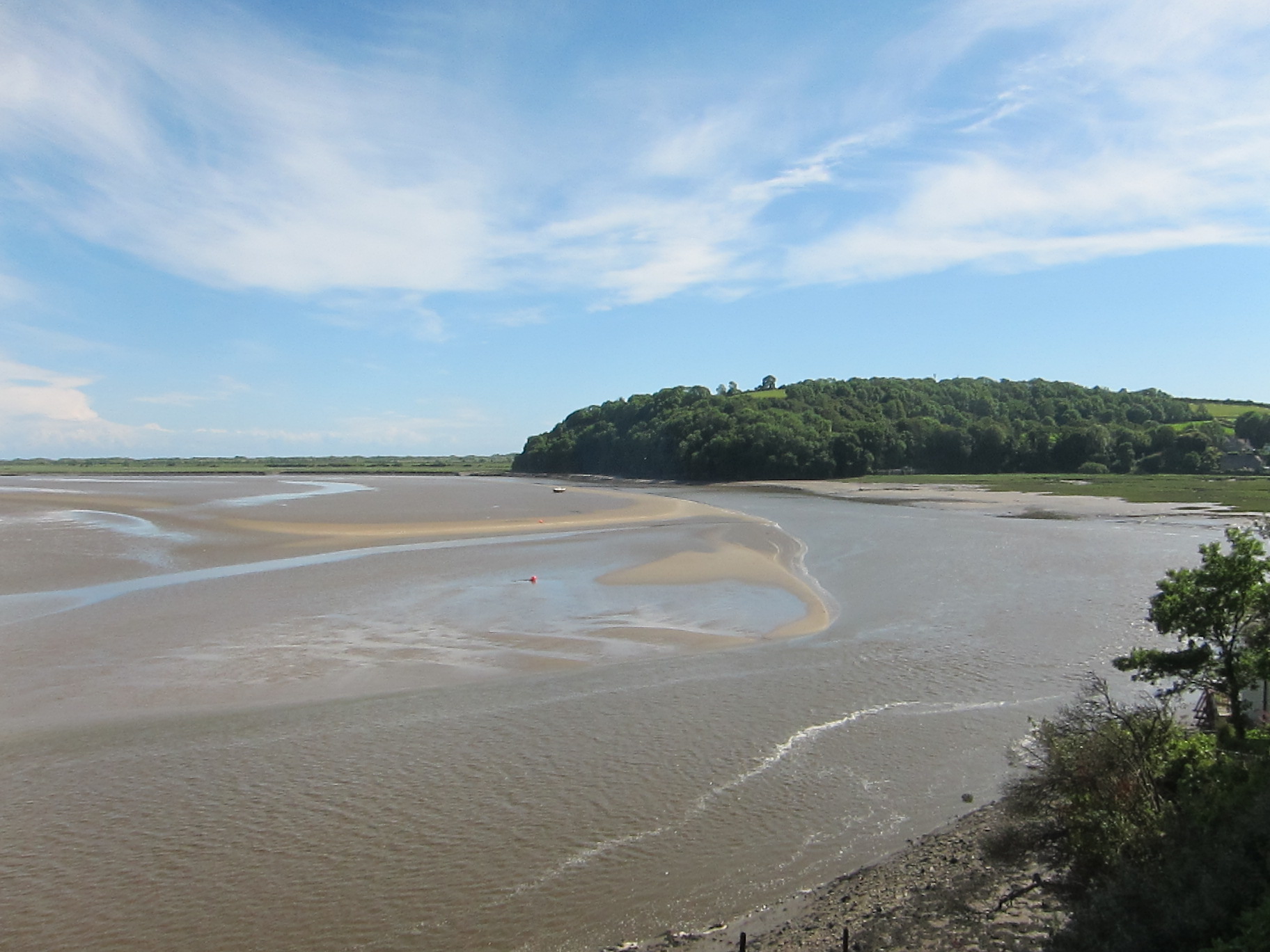
Me with the long stretch of Pentywyn/Pendine sands behind

The sun was now beating down, and although the path was quite tough for the next four miles, the views were superb – it was even possible to see the Devon coast in the far distance, and the Worm’s Head was very clear.

I slapped on loads of Factor 50, having decided, foolishly, against wearing my hat. Since the only lipstick I can find that lasts all day (and protects from cold-sores provoked by burning) is pillar-box red, the effect with thick Factor 50 is rather like Coco the Clown.

IMG_4704

Pentywyn Sands – Worm’s Head to far right.

By the time I got to Amroth, I was hot and tired. There was a very welcome pub where I sat on a comfortable chair and cooled down. At this point, my blister was still intact.

At Amroth, I began the official Pembroke Coast Path. The beach looked inviting, but the tide was coming in and there were lots of groynes. I did not want to find that I could not get out at the end and have to backtrack, so I stayed on the cob. The path climbs up again, then down onto the road into Wiseman’s Bridge, after which it winds around the promontory, then through a very odd cave (formerly the railway tunnel, I think) with bizarre red lighting.  This brings you onto Saundersfoot beach, which, happily, you can walk over.

IMG_4737

Beach at Saundersfoot.

I arrived at the new Air B & B, keen to eat and put my feet up. It is very disappointing – absolutely miles from the bus or train station, and when I arrived, the key-lock number did not work. I tried, and one of the neighbours tried. There was no phone signal, so I had to drive to the nearest pub, to log onto Air BandB and check the number. I was definitely trying the right combination. I had to track down the owner and get him to come out.  He used an entirely different code. There is no TV aerial, and the injunction on the info sheet to play board games instead is rather limited for a single person. The DVDs provided as an alternative are all what you might call family viewing – eg Mrs Doubtfire!  I am not a big TV watcher, but I do like some shows. The owner slightly redeemed the situation by offering me a lift tomorrow morning to the station, now it transpires I cannot walk there very easily. I am going to have to rejig my timetable.

Weather superb – 14.5 miles and another Silver day.

Advertisement
Day 112 – Llansteffan to Talacharn/Laugharne 9 June 2019

Day 112 – Llansteffan to Talacharn/Laugharne 9 June 2019

I am so glad to have met James and Anita. Apart from them being extremely interesting and nice people, we were able to circumvent the difficulties of Sunday public transport in Wales. There is a ferry from Glan-y-fferri (who’d have thought?) to Llansteffan, so we decided to begin walking there, and left one car at Talcharn/Laugharne, underneath the imposing Anglo-Norman castle. The countryside is littered with these twelfth-century strongholds, built by the Marcher lords who had licence from William the Conqueror to take as much land from the Welsh as they could and hold it on terms much less onerous than the land they held from him in England. Talacharn castle is more-or-less opposite Cydweli, where we had tea yesterday. The pair of fortresses guard the entrance to the Tywi estuary.

Llansteffan is a lovely little village. We arrived about 9am and set off towards the shore. We agreed to walk separately, as I am slower, and it is very tiring to walk at someone else’s pace. Just as we left the village, we could hear the church bells ringing and see yet another castle.

Church at Llansteffan

The sky was blue, the view over the estuary was amazing, across Cefn Sidan, all the way back to Llanmadoc, and the Worm’s Head beyond. The path starts by running through woodland – my favourite kind of walking – woodland overlooking the sea.

Woodland near Llansteffan

After a couple of miles, the track turns inland, up yet another estuary – this time the Tâf. The walk was largely uneventful – more road walking than is entirely pleasant, my knees do not respond well to tarmac. The poles seem to help, though. By and large, the signposting is good. Carmarthen, like Newport, has the tops of the fingerposts in bright yellow, which helps. I admired a flock of domestic ducks in one field (although Anita told me later they were geese). Surrounded by buttercups they had the air of an advertisement for wholesome food.

Passing that farmhouse, the signage was not brilliant. One gets the impression that some of the landowners are not that happy to have the Coastal Path traversing their fields – poor signs, unoiled gates, bullocks in the field etc, often give the impression that walkers are not welcome. I cannot help thinking that they get the money, so should be a little more accommodating. Of course, many farms are well-arranged for walkers.

Ducks or geese, on a farm near Tâf estuary.

Having looked at the map, it seemed to me that a short-cut was possible – rather than following the official path for about a mile, another public footpath served as one side of a triangle. Sadly, short cuts always mean long delays. The field, although a public footpath, was wall-to-wall bovines. Not just a few, but scores.  All far too interested in me. I trekked to the side of them, and entered another field – I could see the path about 200 yards away, but there was no way out of the field without going through the cattle. I turned back and took the official route. It went through another cattle field, but they were tucked into one corner, and rather more docile. I crossed a couple more fields, lots of grass, presumably for sileage, and sat down to eat my lunch. I discovered later that James and Anita had stopped in exactly the same spot!  Several fields later, the path decanted onto a minor road. As I turned left, I could hear ferocious barking.

Dogs, unlike cattle, do not bother me, but the two that came trotting out of a farm yard, onto the public highway were ugly customers. One was a labrador, normally a docile breed, and the other a collie. They were not docile at all. They barked and snarled and circled me. The worst thing is to show fear, so I breathed slowly and began talking to them,  in both English and Welsh, although I kept my poles in front of me. The lab looked as though she might have pupped recently, so perhaps she was feeling protective.  I struggled to pass them.  Then they began to calm down as I kept talking as soothingly as I could. The lab came close and wagged her tail, but I was not going to fall for that and try to pat her.  I hit on the idea of throwing the apple I had been eating, in the hope they would bound off, but only one fell for it – I was now trapped with one in front and one behind. Not such a good plan. They then bounced ahead and to my left. I hurried past and arrived at a farm gate. Clearly, I had missed the path. A young girl pointed in the right direction (the opening the dogs had shot down). I thanked her, and observed that the dogs were rather fierce to be allowed out on the road, but she obviously could not care less.  The brutes had raced off by now, but I was glad to nip down the path and clang the kissing gate firmly behind me. More open fields took me into St Clears. There was a lot of interesting information about the industrial past of the estuary – it is almost impossible to imagine these quiet, rural areas as once having been hives of industry.

The path runs alongside the main road, but a lot of effort has been made to keep the track safely behind the hedge. It then diverts through more fields, used for trail bikes, it seems, and then some of the loveliest fields of the day. I suppose they are ‘set-aside’ land, as they were brimming with wildflowers – buttercups, grasses, yellow-rattle, flag-Iris, red and white clover, all a-buzz with insects, including bright blue damsel fly-type things, bees, butterflies (although not so many of them as you might expect). Butterfly in Welsh is pili-pala – one of my favourite words.

Set aside farmland, near St Clears, full of flowers and grasses.

Passing through several fields, you could tell which had been set-aside longer, and which were perhaps in the first season. There was another strip of woodland, overlooking the estuary, then down a lovely green-lane, before entering the well-kempt wood just north-east of Talacharn, which is, of course, famous for Dylan Thomas having lived there. I know it is sacrilege, but he is not one of my favourite authors, so I did not detour to see his writing shed.

Carmarthen Bay, near Talacharn.

I arrived back under the castle at about 4.30.  Most of the tea-shops were no longer serving. Query, why would you turn away custom on a sunny Sunday in June?  The season is not that long, surely you want to make as much as you can?  One was open, offering an interesting fusion – Asian street-food and tea and cake. Excellent lemon drizzle. Knees a bit grumpy after so much road walking.

Cat has returned, having ignored me last night. Unusually for me, I have a massive blister, just where my right instep meets my heel – my sock must have got a fold in it.  Shan’t be bursting it though. Hopefully, it will subside overnight.

Total distance 14.2 miles, and gorgeous weather.  Another Silver day – perfection marred by the quantity of road walking.

Day 111 Penbre/Burry Port to Glan-y-Fferri 8 June 2019

Day 111 Penbre/Burry Port to Glan-y-Fferri 8 June 2019

The rain last night was so bad that I let Cat in. I was firm with him: 1. He had to go out when it stopped raining, 2. He had to go out when I went to bed, regardless of the weather. 3. I would not feed him. 4. He definitely was not allowed into the main bed-sitting room, but had to stay in the conservatory.

Those of you who have experience of cats will not be surprised to hear that I was woken at 3.42am by Cat uncurling himself from the small of my back, jumping off the bed and demanding to go out, having dined on the cooked chicken I bought for my packed lunches.  How do cats do it? From pleading to be allowed to take shelter from the storm, to the complete run of my accommodation in a few hours!

Today was definitely one of those days when I have to pinch myself to believe I am not dreaming – everything was just right – even getting lost a couple of times was no hardship.  I drove to Glan-y Fferri, intending to catch the 9.10 train. I allowed plenty of time to get there, as the narrow lanes can be confusing – in fact I went down one so narrow that a pedestrian and her dog could hardly pass me – it got steeper and steeper and narrower and narrower, and I was lucky nothing came in the opposite direction. I was early, so I sat in the car for a few minutes, then cursed myself as, if I had hurried, I could have caught the 8.24. However, the forty minute wait was a blessing in disguise, as two more walkers turned up. They were doing the same stretch as me today, and, after a bit of chat, we realised we are staying at the same place. We did not walk together – it is very tiring to pace yourself to someone else, and I could tell they would be faster than me.

I joined the path more-or-less where I left it yesterday, going round the dock at Penbre. The dock was created by local entrepreneurs, George Bowser and Thomas Gaunt in the 1810s for shipping coal from Gwscwm and Cwm Capel. It was formed by diverting water from the Derwydd to scour a deep tidal harbour, with sluices for clearing the silt.  The original owners failed, but the site continued to be viable until the early twentieth century by which time it had silted up too much to allow big vessels access.

IMG_4531

Penbre Dock

Quite a few boats were bobbing in the little dock, as I turned west, inland of the sand dunes. Like yesterday, much of the path was tarmac aimed at cyclists.

IMG_4551

Some sort of cycling challenge in progress in Pembrey Country Park.

It runs into a country park, with lots of tracks and trails, and even, rather bizarrely, a dry ski slope. I stopped on a hill to admire the view and eat some muffin. After a couple of miles, it decants onto Cefn Sidan, a Blue Flag beach which is absolutely superb – almost flat with sands graduating from gold to white, living up to their Welsh name of ‘silk’, and lots of low breakers after yesterday’s rain. It was a little marred by the quantity of jelly-fish, but the views across to the Gower on one side, and the headland at Pendine on the other were wonderful.

I was amused by a sign warning against the hazards of too much sun.  I think I will start a new page, with best sign of the day.

The rain had rolled away overnight, and the sky was mostly blue with broken cloud. The wind was quite fierce though. I could see my train companions far away and kept an eye on them, as the path turns back from the beach, into Penbre woods. I did not see the path, and was wondering where it might be when I saw that James and Anita had turned back. They told me they had walked a good way further on, and that we must have passed the track. We turned back and took the first path off the beach, but that was a dead-end.  We went back a bit further, and left the beach at a clear track, which took us into the wood. We consulted the maps and the GPS, and agreed that about a mile in the same direction would take us to the edge of the wood.  I decided to eat my sandwiches, whilst they walked on.

Ten minutes later, I started out, but before long I got lost in the hopeless maze of tracks that weave in and out of the wood, mainly designed for cycling. There was neither jot nor tittle of a sign, after the earlier section had been so clearly marked. After I while I was sure I was going in the wrong direction, so I whipped out my compass (when I say whipped, I mean I unpacked my entire rucksack to find it at the bottom). I was going south rather than north, so I turned around and took a different track, slightly reassured when some passing cyclists told me I was going in the right direction for Cydweli, but they did not mention it was a circular track.  At least a mile and half further on, I finally came to T-Juncion with a sign. Coast Path – going in both directions. As I was consulting the map, a couple of locals came up and put me on the right path.  She warned me about a field of cows. ‘Friendly or grumpy’, I asked, gripping my poles in business-like fashion.

‘Oh, quite tame.’

Nevertheless, I prepared my mind. In the far distance, I caught site of James and Anita again – clearly they had been lost, too.  The track turns across the old airfield, which is huge, and literally riddled with bovines. Naturally, some were on the path. I decided that holding my poles in front of me would make me look bigger.  I walked amongst them but, fortunately, although there was a bit of snorting, none of them moved.  The track then carried on to Cydweli – hard underfoot again. It was 3.30 by now, and I was keen for a stop. I found a very nice little tea-shop, where my friends had already imbibed, and ate a couple of Welsh cakes.  There next section was straightforward, a bit of road walking then up a track to Llansaint, through the little village, with superb views opening up of the estuary, then through more fields and down into a lovely, narrow little wooded glen.

IMG_4608

Glade near Llansaint, Carmarthenshire.

I was glad of my new boots – after yesterday, everything was slippery.  A steep climb up the other side, then though more fields, mostly well-marked, although I did go the long way round one of them, before coming into another glade.

I could hear some cows bellowing, and was glad when the path turned away from the field gate, although all it did was go ten yards down the hill, then enter the field just below where the cows were congregating. They were noisy, and not friendly. The mud was appalling, real boot sucking stuff, so even if I had wanted to run, I would not have been able to. I was glad  of my poles, that kept me upright when I might have fallen. Fortunately, the beasts were more sound than action. I went through the kissing-gate and followed the sign, which seemed to lead across a very steep and muddy field. The path was so muddy it was hard to walk, but to go off the path was impossible as the slope was enough to turn your ankle. I slogged along for about a half a mile, getting muddier all the way, till the path ended in a barred gate. I had obviously missed the route. Unable to face returning, I shimmied under the barbed wire onto the lane. The path then meanders through the back of Glan-y-fferri, back to the car park.

Just as I arrived back, the other couple did and we had a chat to Mrs B & B. Cat emerged, and I had to ignore him as she once again insisted that he was not to be encouraged. I felt like a guilty spouse, pretending not to know my lover.

Distance 15.3 miles and a Silver day.

Day 110 Gowerton to Penbre/Burry Port 7 June 2019

Day 110 Gowerton to Penbre/Burry Port 7 June 2019

I had a super drive down yesterday – just on six hours, which, considering I did not go near a motorway, was pretty good time.  I chose a leisurely route, with time for morning coffee at Chipping Norton, then along the A40 all the way to Caerfyrddin/Carmarthen, although the journey was marred by the news that the Ford factory at Pen-y-bont ar Ogwr/Bridgend is to close with the loss of 1700 jobs. What with that and the works at Porth Talbot being under threat, the whole economy of South Wales will be badly hit, and it is already a poor area.

Talking economics, rather than staying at ordinary B & B, I am self-catering, in part to keep the cost down. This is not a cheap hobby if I eat in cafes and pubs twice a day for ten day at a stretch.  My first location is just outside the town, on the coast path route. I have a little suite to myself – bedroom, bathroom, kitchenette, conservatory, and a deck overlooking the river. It was warm enough yesterday to sit out in my shorts – today is a complete contrast.  It has been one of the wettest days of the entire walk – the only days as bad might be the morning at Beachy Head, and a couple of wet afternoons with Chris and Tom in Essex in the winter of 2013/4. The forecast was bad, so I was pleased when I hopped off the train at Gowerton at 8.45 to find that it was overcast, but dry. Between 8.45 and 10.15, there were no more than a few flurries, but by 11.00 we had moved through ordinary rain to what some of my friends call double rain.

The path is straightforward. I can see why the M4 relief road has been cancelled – the back road out of Gowerton is serving as an alternative route already – despite being single track in some parts, there was a constant stream of traffic in both directions. Eventually, the path veeredoff into woodland, then a footbridge over the A48, and through more woodland, before joining the main road as it crossed the Llwchwr estuary. The original rail crossing was built by Isambard Kingdom Brunel, and much of his work remains, although it was updated in 1907.

Llwchwr Estuary

Original built by Brunel.

I was excited at the prospect of seeing the Llanelli Coastal Park – twenty (20???) years ago, it was one of the Millennium Commission projects that I worked on. Previously, the whole area to the south of Llanelli was industrial wasteland, but now it has been reclaimed, and there is a track running through for cyclists and walkers. I would have preferred the track to be a bit narrower, and perhaps less of it tarmac’d. It is hard underfoot and does not blend into the landscape, but I suppose it is easy cycling.  The path runs through wetland, past a golf course, and sometimes comes close to the shore, although for long stretches the raised railway obscures the view.  There are some nicely-designed seating areas, with slate and interesting levels in the grass, and in some parts, a profusion of wild-flowers – lots of cow-parsley and oxe-eye daisies.

Info on Llanelli wetlands

Copious bird-watching opportunities…when it is not raining.

Near North Dock, I could see the leisure centre, which I knew had a café – despite having brought sandwiches, I was cold and wet, and desperate for a cuppa. I was worried it might be closed – not many people would want to be out in today’s weather, but actually, it was packed, and was rather fancier than I anticipated. I opened the door, and the waitress did her best to hide her lack of enthusiasm as I stood in the doorway with water pouring off me.

I had a bowl of soup, then had no alternative but to put my wet coat back on and march off purposefully. I did not hang about and got to Penbre/Burry Port station around 2.30. I had to wait half an hour for a train, which was a cold and dispiriting experience, but at least it was on time.  I am sitting in my little conservatory, with a stray ginger cat for companion. I was asked by Mrs B & B not to encourage it, but although I ignored its cries yesterday, I couldn’t bring myself to leave it out in this weather. I hope I don’t get thrown out for breaking the rules.

Distance 11.6 miles and a Bronze day.

Update – 5 June 2019

Update – 5 June 2019

No – I haven’t been put off my coast walk by mad cows, but I have had no time to walk since last July.  In the meantime, I have completed the Icknield Way, and have sent my second book off to the publisher, so I haven’t been idle.  Looking forward to a good chunk of walking over ten days, from Gowerton, across the Llwchwr estuary into West Wales, and, on day five, I should reach the Pembroke Coast Path.  Annoyingly, all the luggage transfer services go in the opposite direction, and since I have given up carrying my pack unless there is absolutely no alternative, I am having to do a complex set of bus and train manouevres each day, which has taken most of a day to work out, given the paucity of public transport in the area – and certainly no buses on Sundays.

Once again I have new boots. I love the Zimberland fit, but I have worn away the soles again.  I am trying a Scarpa pair – they are a narrower fit, so I have gone up a size. The assistant in the outdoors shop was shocked when I told him I wear two pairs of socks, but given my blister-free history, I am not changing now.   I am also trying poles – I have to admit, more for fending off cattle than anything else, but many people do recommend them. I have got folding ones so they can go in the back-pack. Not the twisty ones, I found them to be hopeless when I used them before. Super-light, Black Diamond Carbon poles – only 140g each, which is astonishingly light.

The forecast is not brilliant, but no point in worrying about that.

Day 109 – Cheriton to Gowerton 25 July 2018

Day 109 – Cheriton to Gowerton 25 July 2018

We had a great celebratory meal last night, at an Italian restaurant in Mumbles, and I confess I was a little heavy-headed this morning. We hoped that today might be the lucky day for finding an 11 o’clock coffee stop, but alas, no joy.

We left one car near the station at Gowerton, then came back to the pub we finished at yesterday, and turned off down the lane where, had the sea wall at Cwm Ivy still been intact, we would have emerged from the salt-flats. To begin with the walk meandered around the flats again, but then entered farmland and some pleasant wooded areas.

However, it was not long before the path joins the road at Crofty.  We arrived there around 10.15, but neither pub was open.  The door of one was actually open, and a lady was laying tables, but she did not feel able to serve us coffee – nothing could be done before twelve.

Somewhat disgruntled, we marched on. Before long we saw a hiker coming towards us and stopped to talk. She is doing the Wales Coastal Path, but in the opposite direction. We talked about the optimum number of days to do on a trip. I said that in some ways, I’d like to do a really long chunk of two or three months, but that in fact, the longest stretch I have done was two weeks, by which time I was thoroughly fed up.  Her advice was that, once you push through the two-week mark, walking becomes your life, and you sink into it completely.  Not sure – one to think about if I have an extended period of free time – not likely in the immediate future.

The road was quiet to begin with, but became busier.  In parts, you can walk to the side on the old railway track, now a cycle-path, which used to serve a branch line from Gowerton to Penclawdd, initially installed to move coal from the mines in the Morlais valley. It is hard to believe there were once mines in the Gower – the Welsh Development Agency has done a fantastic job of removing all signs of this once pervasive industry.  Before the railway, there was a canal, which brought coal from inland to the dock, for transport to sea-going vessels.  There is the merest ghost now of the dock to be seen at low-tide.

Some effort has been made to make the route pretty with wildflowers, and it was good to see across the estuary, but after yesterday’s gorgeousness, today was bound to be a bit tame. Nevertheless, the weather was pleasant, and having my brother-in-law for company made it a silver day.

12 miles.