Day 47 – Keswick to Sheringham 5th May 2014

Today was an excellent finish to the weekend. My original plan was to go as far as Cromer, but on consultation over game pie in the pub, we decided that that plan lacked ambition, so settled on Sheringham as the day’s destination.

It was an absolutely glorious morning, and we workedIMG_6152 up an appetite for breakfast by taking a brief detour to the ruined Cluniac Priory at Bacton. The sky was vivid blue, enhancing the white stone of the ruined Romanesque building. We couldn’t get very close, as it is on private land, but the old gatehouse was accessible. The local architecture relies very heavily on walling of flint cobbles, and the gatehouse and surrounding cottages were largely constructed of this, with stone or brick quoins.

We set out along the beach around 9.45 am. The tide had not fully retreated, and as the coast is very uneven in the amount of erosion that has taken place, there were points when we were dashing across the sea wall between waves – not always successfully. I got a good shower at one point.Early bath

What I had taken yesterday to be many different types of stone on the beach turned out to be almost all flint, in various states of erosion. I did not know that flint could come in so many different shapes and shades, having assumed it would all be shades of black and white. Tom was hoping to find some amber, which apparently is not uncommon on this coast, but had no luck. The cliffs were climbing in height to a couple of hundred feet, mainly of very soft sand and clay with frequent landslips.

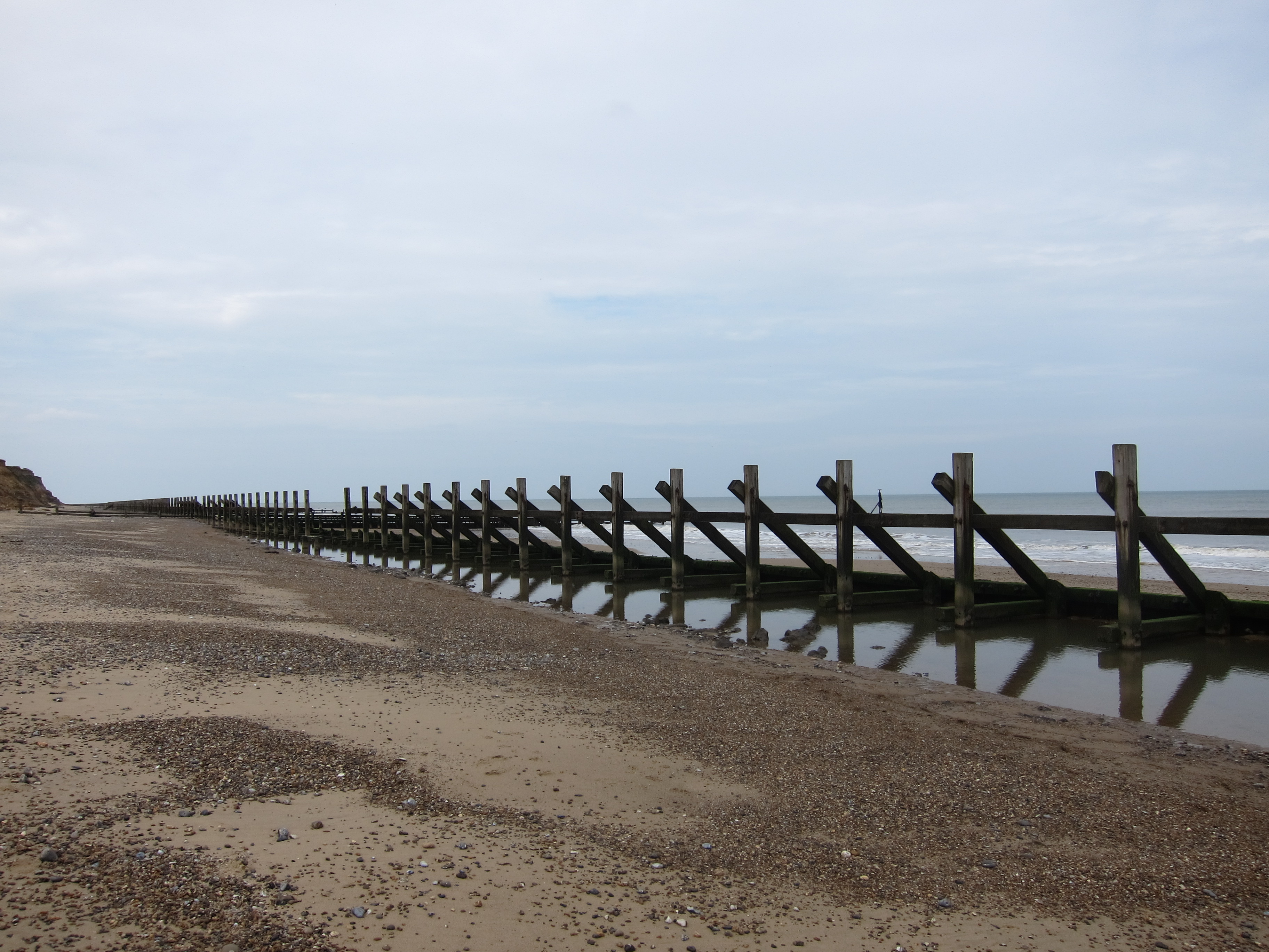
There were various types of groins, one sort being built in a type of zig-zag, known in East Anglia, Tom informs me as “crinkle-crankle”.   What a marvellous new word – I shall be looking out for opportunities to use it in conversation.IMG_6170

There were lots of people and dogs about. I have noticed that everyone in Norfolk seems to have at least two dogs – the one dog family was rare.

We saw some turnstones, a couple of oyster catchers and a bar-tailed godwit, but not many birds overall, not even many seagulls.

The sun was out and the wind remained light, and from the west so it was very pleasant. At one point we had to scramble round some very soft clay-ey rocks, much to the detriment of boots and trousers, but the walk was not demanding. A sandwich of the famous Cromer crabs was had in Overstrand, just to theIMG_6240 east of Cromer, accompanied by excellent Norfolk Apple juice, then a brief stroll took us to the prom at Cromer. Cromer is a very traditional sea-side town – early nineteenth century housing on the cliff tops and a pier from the early twentieth century. There were plenty of traditional sea-side venues and just enough wind to make sure of red faces.

We passed the Beeston Bump, at 207 feet the highest point on the Norfolk coast, just before arriving in Sheringham in time for the 17.42 train to Norwich. A delightful 14.75 miles, which has taken me well over 800 in total.

Day 46 – Winterton to Keswick 4th May 2014

Today I saw something I have never seen before in Britain – seals en masse. I have seen the odd one off-shore in North Wales, but never in groups (pods? colonies?). I had heard talk about seals north of Winterton in the pub last night, and Sally had mentioned that it was an area noted for wild life, but I had given the matter no further thought, until, about an hour north of Winterton I saw some people sitting on rocks doing nothing. ThiIMG_6100s is unusual: unless the sun is out and they are sunbathing, people tend to walk on beaches, or, if they are sitting, they are fishing. As I came closer, I saw what I thought was a black labrador playing in the waves, and assumed that the sitting people were waiting for their pet, then, a bit closer I realised it was a seal playing in the shallows.

A hundred yards further on, what I had taken to be rocks were, in fact dozens, if not over a hundred seals of all shapes, sizes and colours, basking on the sands. The vast majority were having a Sunday morning lie in, but the odd few sat up, scratched and waddled into the waves. It was a magnificent sight and repeated a few miles further on where a different, slightly more lively colony were also lying on the beach, completely impervious to the sight of me walking past. IMG_6119

The was spent entirely walking along the beach, initially, it was firm enough but there were a few places where it was hard going over soft sand. I had an unexpected wetting when I stopped to throw a stick for a friendly labrador and didn’t spot the wave coming up behind me.

The cliffs gradually changed from white sand dunes to golden cliffs by the time I reached Hapisburgh. (This is apparently pronounced “Hazeborough”).  The light house is a lot closer to the sea than it used to be!IMG_6134 The wave damage to the caravan park there has been huge, the cliff is covered with dangling pipes, wires and bits of fencing, with lumps of concrete all over the beach, all suggesting a fairly recent fall. After Hapisburgh the sea defences are formed of a rather ugly line of fencing that effectively cuts the sea off from the foreshore. I hurried along this bit, my feet starting to ache with the effort of walking on sand. IMG_6144

I climbed up to the cliff at Walcott Gap and walked through a timeless stretch of countryside, a ploughed and harrowed field with a church behind and an elderly man digging and delving in his allotment.

Keswick, where I am staying, has rather a good ice cream parlour where I treated myself to some vanilla and honeycomb, but it was plagued with midges this afternoon, as the weather has turned rather muggy. I am awaiting the arrival of Tom who is joining me for the walk to Cromer tomorrow.

22km today, around 13,75 miles which was easy after yesterday’s 20.25 miles. Distance is influenced by the availability of accommodation!

Day 45 – Lowestoft to Winterton-on-Sea 3rd May 2014

It’s definitely been a game of two halves today, with this afternoon absolutely blissful, and this morning rather less so.

I am finding that where there aren’t local train services linking towns on the coast (as there were in the south east) it is complicated and expensive to use the car, as I have to get a bus (few and far between) or a taxi (ruinously expensive). I therefore decided to try walking with enough stuff in my pack for a long weekend. Of course, I have walked with enough gear for a week in Wales and on the West Highland Way, but I was a good deal younger then, though maybe not fitter. Anyway, I decided to give it a try this weekend, so with my shiny new backpack (see equipment section if you are interested in the minutiae of packs and packing) I leapt on the train at Liverpool Street, to be decanted at Lowestoft at around 7.45 last night. My B&B was only five minutes’ walk (see review).

I set out at 8.30 sharp, and retraced about a hundred yards that I had done last time. Lowestoft is not beguiling, and the wind was, if not howling, at least moaning. The first few miles were along the sea wall. In due course, I came to Lowestoft Ness, which makes this a red letter day, as that is the most easterly point in Britain. I have done the most south easterly (South Foreland) and should bag the most south westerly later in the summer.IMG_6006

The sky loured, but it didn’t actually rain. At the beginning, walking along the sea wall was fine, but it began to get narrower and more slippery as it went on, with warnings about using the path at one’s own risk, and a few places where the waves came right up and crashed over the path in front of me. The sea wall and cliff paths have been badly damaged by the last couple of winters’ storms and I eventually had to go inland to make a long and very frustrating detour through a caravan site. Not because it was further, but because all of the paths and roads seem to go round on circles with no exit. Eventually, I emerged onto a golf course at Gorleston. I could see Gorleston point and Great Yarmouth inland of it.

Great Yarmouth is no more appealing than Lowestoft. Both towns seem very poor and there was an air of deprivation about the whole place. I walked up the west bank of the Yare amidst light industry and deserted coastal type buildings, to cross the river some two miles inland. Were I a purist, I would have walked right down to Gorleston Point on the east bank of the Yare, but I’m not, so I didn’t.

Today was market day and the town square in was very full. I walked through it stopping in Boots to replace my toothbrush. In the interests of packing light I had a tiny travel one with me, but it more or less disintegrated and left me with a mouth full of bristles this morning, which was quite horrible, so be warned, and do not economise on tooth brushes.

Down on the sea front again, at Scroby Sands the scenery improved over the dunes, towards Caistor, which still has the remains of its Roman fort. I saw a couple of chaps thatching a sea side shelter.  I have never seen thatching actually being done before. It looked like hard work – balancing whilst handling armfuls of reeds, about 3 – 4ft long.IMG_6041

Out at sea I could see the Scroby wind farm. As I have said before, I think, I rather like off shore wind farms. Once I passed Caistor, I walked along the beach, and this is where the afternoon triumphed. The beach was superb; a long, flat stretch of firm golden sands as far as the eye could see. The sun had more or less emerged and the wind had dropped so that the sea was a vast expanse of blue with a fringe of white.IMG_6056

On this day last year I put my feet in the water for the first time, and I decided to do the same today. It was marvellously refreshing, but achingly cold. Nicer under foot than the pebbles at Chichester harbour had been.IMG_6058

I was not tempted to do more than stand in it for twenty seconds before putting the boots back on.

I walked along this magnificent stretch of coast for some eight miles to Winterton-on-Sea, a quiet fishing village with a very pleasant atmosphere (and a lot of adders!) I am now sitting sipping a cuppa in the Fisherman’s IMG_6078Return (see review) having covered 20.25 miles.