Day 115 – Freshwater East to Castellmartin 13 June 2019

Day 115 – Freshwater East to Castellmartin 13 June 2019

Owing to a complete misreading of the timetable for the shuttlebus, I did not walk yesterday. Having waited a good half hour at Castellmartin, and been offered a lift in completely the wrong direction by a very helpful lady who even tried to ask one of her neighbours about the bus, I gave up and went to Pembroke to admire the castle and eat cake instead. To be honest, after Tuesday’s marathon which had me seriously contemplating the sanity of this whole project, a day’s rest did me no harm – although if I had planned it, I would have had a lie-in.

Having solved the mystery of the timetable, I went back to Castellmartin this morning, left the car, and caught the bus to the terminal, then all the way back to Freshwater East – the whole thing took three hours. By 11.30 I was 200 yards from the chalet, and had not walked a step.

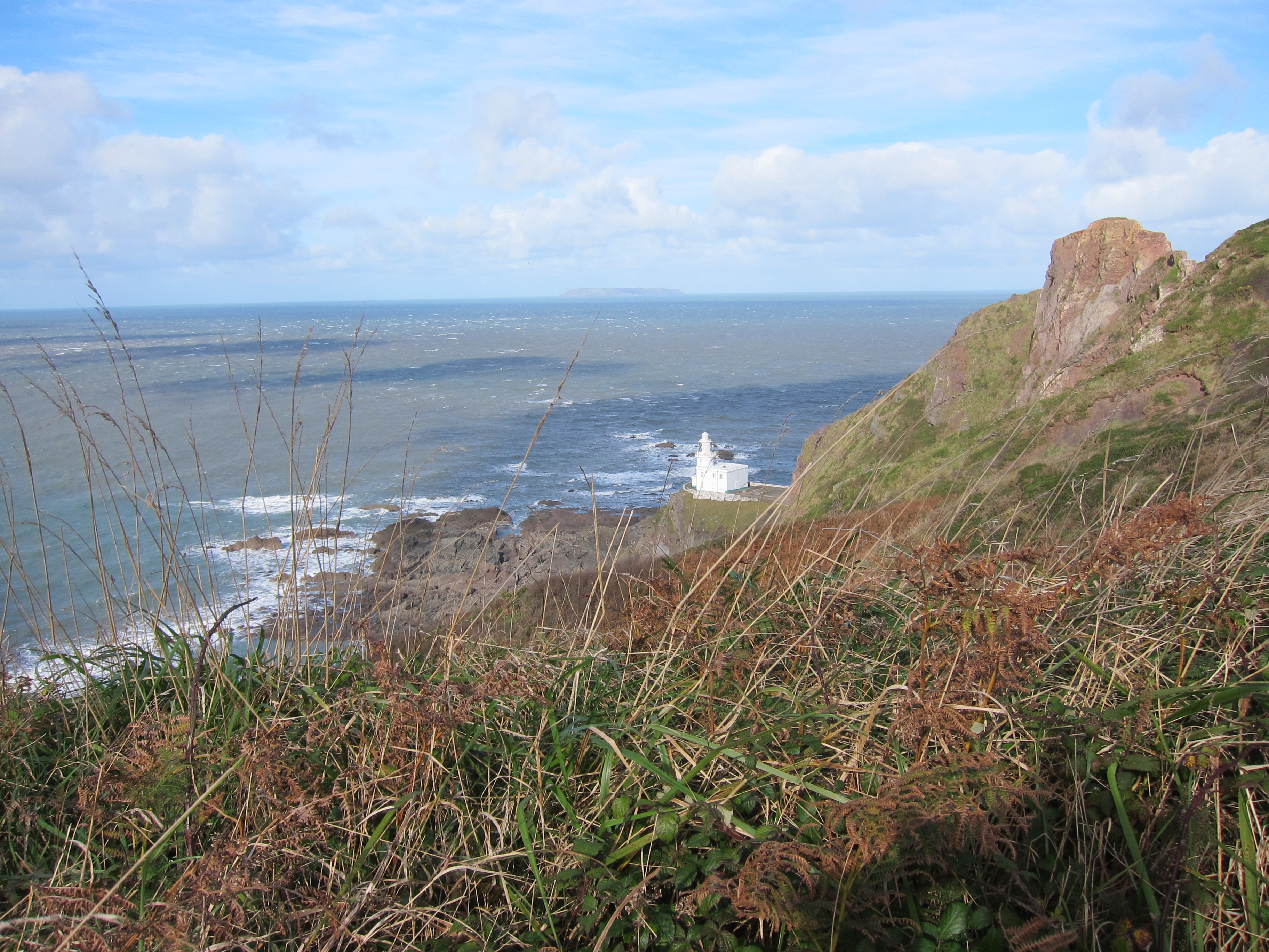
I fortified myself with more coffee and cake, and set off up the headland. I saw more walkers today than all the other days put together. The weather was perfect for walking, although not so good for photos as Monday. It was broken cloud, with a light breeze and some sunshine coming and going.  Eventually, I even thawed enough to take off my waterproof. I don’t generally feel the cold, but it got into my bones on Tuesday, and the chalet is a dank, north-facing, shady place, that will never have any sun in it, and whilst I can’t say it is positively damp, it has a depressing chill. I sit on the sofa huIMG_4787ddled in the blankets thoughtfully provided by the host, in lieu of heating. The views were superb – the cliffs on this stretch are of the steep up and down, with long flat stretches along the top variety. I could see all the way back to Llanmadoc Hill on the Gower again. It was another wild-flower fest – red clover, some sort of sea-side loving borage, tiny little rock roses and primula calendula. IMG_4813I forgot to mention that on Monday I saw a tawny owl, down near the set-aside land at St Clear’s. I hoped for choughs today, but although there were hundreds of crows, their legs were stubbornly black. I may have to touch up a couple of photos.

The path drops down to Stackpole Quay, apparently the smallest dock in Pembrokeshire, then on to Barafundle Bay which advertises itself as the best beach in Wales. It was certainly delightful, although I think there are others as good – Porth Oer, near Aberdaron (although I may be prejudiced) but even the next bay along, Broadhaven. was just as gorgeous – rolling golden sands, clear water and impressive cliffs with caves and arches. There is one very odd feature on top of the cliffs – a deep, round hole, about thirty feet in diameter, which appears to be completely natural, and goes almost all the way down to the water.  There were other inlets with caves, and the sound of seagulls in them echoed strangely. IMG_4801

The MoD operates considerable swathes of cliff for a firing range and today was one of its days for closing them to the public so I walked around the inland route, which is no hardship at first, because it takes you past the lily ponds at Bosherton – I have never seen so many water lilies. I stopped at a little church – St Michael and All Angels- one of the many Norman churches in the district, built by the Norman Marcher lords, who were encouraged by the English king to take as much Welsh territory as they could. Tucked away in a corner was the tomb of a woman the leaflet named as one of the dowager-duchesses of Buckingham, but I don’t think that can be right – the clothes predate any of the duchesses.  I shall have to investigate!IMG_4822

The MoD has provided a reasonable path diversion, so that you are not obliged to walk too much on the road. There was a pleasant enough old trackway, for part of the distance, then a permissive path across fields.  Much of it was arranged with a three-foot wide stretch of path, with a fence to one side and dire warning about not touching military bits and pieces. Obviously, one of the few stretches without a fenced off path was a field full of my four-legged friends. I contemplated the alternatives – a long extra section on tarmac, or a scramble over barbed wire and along a deep drainage ditch. They looked harmless, mostly lying down away from the barbed wire edge, except for one calf, right next to it.  The worst thing you can do is get between the calf and its mother, which discouraged me going inward of it,  but walking straight it might not please mum either. I took the latter approach, and before I got to it, she called it, and it raced off. Good  – only two more ahead of me.  One ignored me, the other turned its head and waved its horns. The bull was in with his girls and had taken up position near the exit.   To go back would surely make him think I was more of a threat than going forward. I looked at the barbed wire again – three strands – I reckoned at a pinch I could crawl under and leap the drainage ditch.  Fortunately, he did not do more than watch me, as I walked briskly to the gate and slammed it shut behind me.   There was then about a mile and a half of tarmac – so hard on already tired legs.

Tuesday was 16.9 miles, and today a much gentler 10.5 – the diversion reduces the length of the section. I was glad enough to finish though. My knee is causing me some quite severe pain now.  I now need to wrestle with the mysteries of the bus timetable again – the driver explained this morning that there were some errors in it!

Today was a Tin day.

Advertisement
Day 112 – Llansteffan to Talacharn/Laugharne 9 June 2019

Day 112 – Llansteffan to Talacharn/Laugharne 9 June 2019

I am so glad to have met James and Anita. Apart from them being extremely interesting and nice people, we were able to circumvent the difficulties of Sunday public transport in Wales. There is a ferry from Glan-y-fferri (who’d have thought?) to Llansteffan, so we decided to begin walking there, and left one car at Talcharn/Laugharne, underneath the imposing Anglo-Norman castle. The countryside is littered with these twelfth-century strongholds, built by the Marcher lords who had licence from William the Conqueror to take as much land from the Welsh as they could and hold it on terms much less onerous than the land they held from him in England. Talacharn castle is more-or-less opposite Cydweli, where we had tea yesterday. The pair of fortresses guard the entrance to the Tywi estuary.

Llansteffan is a lovely little village. We arrived about 9am and set off towards the shore. We agreed to walk separately, as I am slower, and it is very tiring to walk at someone else’s pace. Just as we left the village, we could hear the church bells ringing and see yet another castle.

Church at Llansteffan

The sky was blue, the view over the estuary was amazing, across Cefn Sidan, all the way back to Llanmadoc, and the Worm’s Head beyond. The path starts by running through woodland – my favourite kind of walking – woodland overlooking the sea.

Woodland near Llansteffan

After a couple of miles, the track turns inland, up yet another estuary – this time the Tâf. The walk was largely uneventful – more road walking than is entirely pleasant, my knees do not respond well to tarmac. The poles seem to help, though. By and large, the signposting is good. Carmarthen, like Newport, has the tops of the fingerposts in bright yellow, which helps. I admired a flock of domestic ducks in one field (although Anita told me later they were geese). Surrounded by buttercups they had the air of an advertisement for wholesome food.

Passing that farmhouse, the signage was not brilliant. One gets the impression that some of the landowners are not that happy to have the Coastal Path traversing their fields – poor signs, unoiled gates, bullocks in the field etc, often give the impression that walkers are not welcome. I cannot help thinking that they get the money, so should be a little more accommodating. Of course, many farms are well-arranged for walkers.

Ducks or geese, on a farm near Tâf estuary.

Having looked at the map, it seemed to me that a short-cut was possible – rather than following the official path for about a mile, another public footpath served as one side of a triangle. Sadly, short cuts always mean long delays. The field, although a public footpath, was wall-to-wall bovines. Not just a few, but scores.  All far too interested in me. I trekked to the side of them, and entered another field – I could see the path about 200 yards away, but there was no way out of the field without going through the cattle. I turned back and took the official route. It went through another cattle field, but they were tucked into one corner, and rather more docile. I crossed a couple more fields, lots of grass, presumably for sileage, and sat down to eat my lunch. I discovered later that James and Anita had stopped in exactly the same spot!  Several fields later, the path decanted onto a minor road. As I turned left, I could hear ferocious barking.

Dogs, unlike cattle, do not bother me, but the two that came trotting out of a farm yard, onto the public highway were ugly customers. One was a labrador, normally a docile breed, and the other a collie. They were not docile at all. They barked and snarled and circled me. The worst thing is to show fear, so I breathed slowly and began talking to them,  in both English and Welsh, although I kept my poles in front of me. The lab looked as though she might have pupped recently, so perhaps she was feeling protective.  I struggled to pass them.  Then they began to calm down as I kept talking as soothingly as I could. The lab came close and wagged her tail, but I was not going to fall for that and try to pat her.  I hit on the idea of throwing the apple I had been eating, in the hope they would bound off, but only one fell for it – I was now trapped with one in front and one behind. Not such a good plan. They then bounced ahead and to my left. I hurried past and arrived at a farm gate. Clearly, I had missed the path. A young girl pointed in the right direction (the opening the dogs had shot down). I thanked her, and observed that the dogs were rather fierce to be allowed out on the road, but she obviously could not care less.  The brutes had raced off by now, but I was glad to nip down the path and clang the kissing gate firmly behind me. More open fields took me into St Clears. There was a lot of interesting information about the industrial past of the estuary – it is almost impossible to imagine these quiet, rural areas as once having been hives of industry.

The path runs alongside the main road, but a lot of effort has been made to keep the track safely behind the hedge. It then diverts through more fields, used for trail bikes, it seems, and then some of the loveliest fields of the day. I suppose they are ‘set-aside’ land, as they were brimming with wildflowers – buttercups, grasses, yellow-rattle, flag-Iris, red and white clover, all a-buzz with insects, including bright blue damsel fly-type things, bees, butterflies (although not so many of them as you might expect). Butterfly in Welsh is pili-pala – one of my favourite words.

Set aside farmland, near St Clears, full of flowers and grasses.

Passing through several fields, you could tell which had been set-aside longer, and which were perhaps in the first season. There was another strip of woodland, overlooking the estuary, then down a lovely green-lane, before entering the well-kempt wood just north-east of Talacharn, which is, of course, famous for Dylan Thomas having lived there. I know it is sacrilege, but he is not one of my favourite authors, so I did not detour to see his writing shed.

Carmarthen Bay, near Talacharn.

I arrived back under the castle at about 4.30.  Most of the tea-shops were no longer serving. Query, why would you turn away custom on a sunny Sunday in June?  The season is not that long, surely you want to make as much as you can?  One was open, offering an interesting fusion – Asian street-food and tea and cake. Excellent lemon drizzle. Knees a bit grumpy after so much road walking.

Cat has returned, having ignored me last night. Unusually for me, I have a massive blister, just where my right instep meets my heel – my sock must have got a fold in it.  Shan’t be bursting it though. Hopefully, it will subside overnight.

Total distance 14.2 miles, and gorgeous weather.  Another Silver day – perfection marred by the quantity of road walking.

Day 93 Watchet to Shurton 27 Oct 2017

Day 93 Watchet to Shurton 27 Oct 2017

I’ve decided on a new ranking scheme for each day – depending on a a range of variables, weather, my mood, views, difficulty, wildlife etc. Day rankings

Today was a bronze day – one up from the standard day. It could have been a silver, but for the incident…

I caught up on sleep last night and was ready to leave by 7.30am as it was just getting light. My B & B was B1 only, so I walked down to the esplanade for breakfast, intending to be the first customer at 8am. Sadly, there was nothing to be had until 8.30. I didn’t want to wait and had had a large dinner as well as lunch yesterday, so I contented myself with a takeaway coffee and an oat crunch biscuit as a substitute for porridge.IMG_2503

The path makes a short climb behind the steam railway, then drops down onto a beach. I was completely mesmerised by the rock formations. It was almost like seeing the creation of the world as the beach had different layers of rock ranging from red sand to shale, then cobbles, then slabs of rock with deep grooves at an angle like frozen waves, which must eventually break up into the large cobbles.

I was walking very slowly as the surfaces were so uneven and slippery, when I felt a warm wet sensation in my right hand. I leapt in the air, the fear of God in me, and gave a shriek. I turned around to be faced by a large dog which had crept up on me – not a clatter of class so be heard. Its owner gave a perfunctory apology and mentioned that it is as well to be aware of one’s surroundings at all times. Thanks – top tip. I refrained from sharing one about the proper training of dogs.

The England coast path is not well signpostedIMG_2521. Although there are signs pointing down to the beaches, it is not easy to know when to leave them. I saw one slip coming down and a lady walking a dog told me take it, and walk through the little hamlet behind the caravan park. With no other clues, I took her word for it. The path climbed a cliff then dropped down onto another beach with even more fascinating rock formations than the first.

It was obvious that the tide, if it came in, would be right up to the cliff, but there were no alternative route signs or warnings before you went onto the beach. Fortunately, although the tide was turning, he sea was a good way out. Enquiries of a lone angler led me back off the beach along another track which undulated gently. I could see a large herd of cows in the distance, but there was no point in borrowing trouble. The path might not go anywhere near them, and in any case, at this time of year, they should be docile.

To my right I could see a beautiful Tudor mansion nestled into the trees. Down to the shore again, then up a little path with a gate at the end and the way marker. I was just opening the stile when I heard the pounding of hooves. Yes, the cow telegraph was in operation and the whole herd was thundering towards me. I clanged the gate shut again as they pressed against it. They weren’t big, but they were young bullocks, and there were an awful lot of them. There was no way I was walking through them.  I looked at the map. There was a considerable detour, but I saw no alternative. I walked down a lane, then along a track and turned back up. Doing three sides of a square, it was not clear whether the path led back into the same field, but it was a big field with a hill in the middle. Hopefully, I would not encounter the beasts again.IMG_2559

Of course, the path did go back into the same field, and I could see the blighters, walking back around the base of the hill. Fortunately, there were two other people coming from the direction I wanted to go in. If I were quick, I could enter the field at the same time as them, and we could give each other mutual support. They got into the field before me, and walked along the far side, where I would have walked if I had not detoured. The beasts thundered towards them. The walkers had sticks and were waving them furiously. In cowardly fashion, I thought I would just nip unobtrusively through the field corner whilst the bullocks were occupied elsewhere, but one looked round and saw me. Half of them kept the other walkers pinned up whilst half began to trot in my direction. I went as fast as I could without running, and nipped through the gate, feeling hot breath on my back.

I was depressed to find that the gate, only of wood, had no proper fastening, but it was enough to e stymied the bullocks. I shot sideways behind the hedge to take myself out of their sight. They set up a halloing and a harrumphing. I felt a bit guilty about the other people, who I could hear desperately shooing them but, peeking through the hedge, I could see the mob that had followed me still hanging hopefully around the gate. I scurried sideways to cross the field out of their line of sight in case they cracked the gate opening.

I could see Hinckley point coming ever closer. The map shows the path going around the edge of it, which was my plan, with a detour of a couple of miles inland to my accommodation. IMG_2563
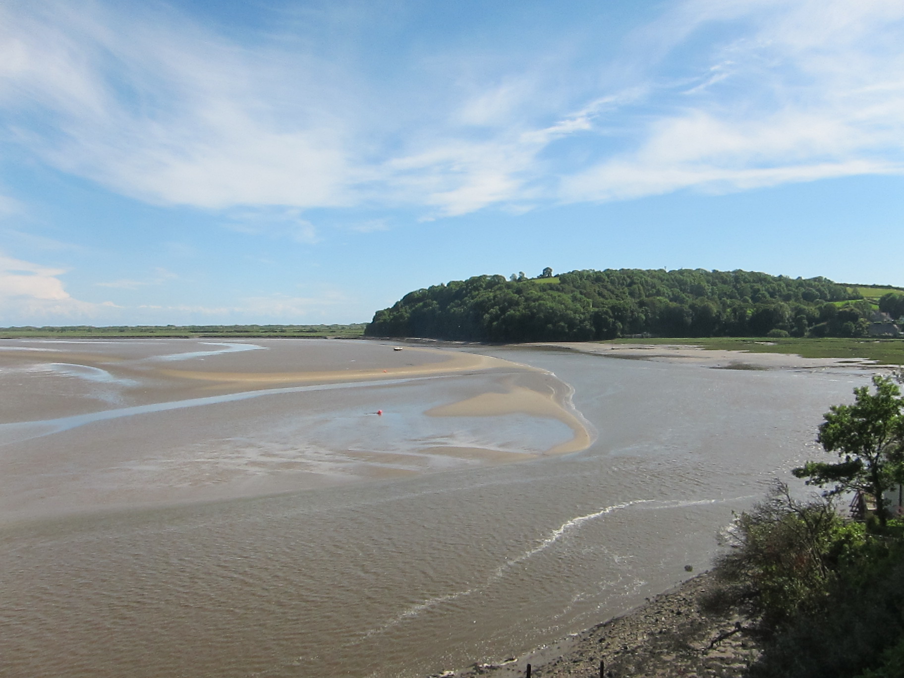
However, the path was closed and brought me the west side of the power station, down a track into Shurton. I arrived at 1.30, having done an easy 10 miles, rather than the 12 I planned, but there is no point doing more this afternoon, as I’d have to backtrack and then repeat it tomorrow. I am planning to  meet Vicki and her spaniel tomorrow for a walk down the Parrett river.


Day 84 – Philham to Clovelly 18th October 2016

Day 84 – Philham to Clovelly 18th October 2016

It rained hard during the night and looked distinctly miserable at breakfast this morning. Jon, who had had a bad night, decided to do a shorter route but I was not to be dissuaded from the full monty and Chris decided to lend me moral support.

It soon cleared up and we have had a bright, windy, blustery day.  It took surprisingly little time to get back to the coast, compared with the hopeless trekking about of yesterday evening.  We rejoined the path about 1.5 miles south of Hartland Quay. Hartland Quay itself is a little strip of cottages, a pub and a hotel, all owned by the local manor.

Lighthouse at Hartland Point

Lighthouse at Hartland Point

There were several steep drops and climbs, but the path soon levelled out towards Hartland Point.

The views were great. Lundy was so clear today that we could almost see the puffins for which the island is famous.  12 miles off the coast, it marks the point where the Atlantic Ocean meets the Bristol Channel and was once owned by the Knights Templar (my completely random fact of the day!)

Around 12.15pm, we rounded Hartland Point, and began walking directly east, after days of north-north-west. We had a leisurely walk along the cliff tops for about 5 miles before dropping into several wooded groves.

Towards Clovelly

Towards Clovelly

I have never seen so many pheasants in my life. They were everywhere: in the woods, in the fields, skittering along the paths. Just outside Clovelly, the scenery becomes very woody, and the walking was lovely, through the fallen beech trees.

Clovelly itself is very odd. It seems to be entirely owned by the local estate and there is a distinctly feudal air about the whole place, which I guess might be friendly if you live there, but I found a bit overpowering.  The village is one long, and very steep, cobbled street from the top to the dock at the bottom.

Clovelly

Clovelly

It is famous apparently for donkeys, although we have not seen any – we were told that either ‘health and safety’ or ‘Europe’ has got rid of them, but I can’t remember which. The street down to the sea front is very steep and slippery – I didn’t much fancy going up and down it twice, so we went down to the pub and stayed there all evening.

On the up side, there are lots of cats, all very friendly and we were impressed by the clever use of baker’s palettes for carrying everything up and down the narrow street.

I was rewarded for resisting Jon’s attempts to lead me astray with a short walk as he had a scary cow incident that I am glad to have avoided.  On tomorrow to the wonderfully named Westward Ho! 13.2 miles.

Save

Day 65 – Portloe to Portscatho 14 July 2015

I can’t say today has been my most successful walking experience ever. The B&B Rachel and I stayed in last night was lovely – a huge Georgian house with beautifully proportioned rooms. It is a working farm so we woke at 5am to the sound of cattle.

We had arranged for Tony the Taxi to pick us up at 8.30 to drop me back at Portloe, IMG_9915and take Rachel on to St Mawes to get the ferry across to Falmouth. I was on a tight schedule to get to St Antony’s Head to take the Place Ferry to St Mawes – last one at 17.45 for last Fslmouth ferry at 18.00. Given our performance over the last few days, I needed to crack on.

The terrain as far as Portscatho, which was just over half way, looked similar to yesterday, with much easier walking thereafter. Total planned was about 13.5 miles, same as yesterday. I set off briskly enough. The usual lack of signposting nearly took me on “dangerous unfenced cliff-path” as several signs announced. Fortunately I spotted the coast path lurking behind a hillock, so I turned my back on “dangerous” and strode off confidently. The weather was poor. Endless mizzle – not wet enough for waterproofs but making the paths greasy and hiding the view. Tony the Taxi had told me to look out for a coffee shack, called the Hidden House around one of the headlands, but, sadly, it lived up to its name, so no morning coffee.IMG_9921

I met a chap coming west to east – obviously a coast path walker. We stopped and chatted – to be honest, after ten minutes, conscious of my schedule, I was twitching to get away. I’d just said good bye when he asked how I felt about cattle.

‘I’m a little chary of them’ I replied. I’ve had a couple of bad experiences.’

‘You can’t be a walker and not have a bad experience with them. That’s the main trouble with the Southern Uplands way…’, a further few minutes on his experiences there. ‘I had to make a big detour to avoid them.’

It suddenly dawned on me that he was talking about today. I snapped to attention.

‘Really? Where?’ He pointed the field out on the map.

‘You can detour here and here. There were mothers and calves.’

I expressed some doubt as to there being calves at this season, but he assured me that, unlike sheep, cows can calve at any time. I was not convinced that his knowledge of the reproductive habits of cattle was accurate, but that wasn’t really the point.

I considered the detour he pointed out. Hmm – a long way round. I decided to go to the field edge and investigate the relative location of cows and stiles.  As I was approaching the field, I saw two other people coming toward the suspect field, from the detour path. I broke into a run to head them off at the stile. If I went through on their coat tails, I should be fine. I raced up to them and began to follow. I apologised for stalking them and explained that I had been warned the cows in that field were a bit troublesome.

‘Yes’, said the lady, nodding vigorously. ‘I met them yesterday.’

Then the man said, in German, ‘Young steers’.

‘Young bulls’ he said, to me. We agreed they could be a bit too playful.

With three of us, however, there were no problems, and I dropped down into Roseland Bay.IMG_9922

Then came a very annoying lack of signage. Three paths and no signs. I picked the right one, decided after a few hundred yards that it was the wrong one, retraced my steps. Tried a second, which soon seemed wrong, as it went too far inland, returned to the junction and was scratching my head when two American cyclists appeared. They told me that there was an acorn sign a few hundred yards up. We agreed the signage was terrible.

I was now concerned about time, so began to hurry. This was a big mistake. The path was greasy and I went down head first, or rather knee first. I fell with some force and hurt my knee and ankle. Not seriously but enough to make myself very uncomfortable. I carried on, feeling very stiff. More signage issues. Three paths with no acorn. This time I made the wrong decision. Eventually, I emerged on a road above Portscatho. I limped along, crosser and crosser, wondering if I could get a bus as my knee throbbed painfully. I contemplated phone Tony the Taxi, but, no phone signal of course.

Just as I crawled into the village, I saw someone waving. Unbelievably, it was Tony Taxi himself, just emerging from a café. I leapt in to the car and he conveyed me quick smart to the ferry at St Mawes. IMG_9925Bless him, he didn’t even charge me. I took a very wet and windy trip across Falmouth Harbour. It is quite a sight – ferries, pleasure craft, yachts, all zooming in and out of Carrick Roads where the Fal, Kennal, Truro and a couple of smaller rivers converge. Apparently, Falmouth is the deepest harbour in Western Europe, and probably the third deepest in the world. IMG_9929On either side lie Henry VIII’s great fortresses at St Mawes Castle, and Pendennis Castle (one of the last royalist strongholds to fall in the Civil War.) There is some superb housing overlooking the harbour too. Heading towards my hotel, I tried to get new boots – the soles on mine have worn too much, I am not getting enough grip for the slippery surfaces. Unfortunately, I couldn’t find any to fit. Maybe in Penzance.

I arrived at my hotel, to find it is closed until at least 4pm. So, I’ve decided on late lunch/early dinner, then rest all evening. Just had an excellent risotto. Can’t have fish and chips every day…